Less-than-perfect ski outing was still great
Published 11:36 am Thursday, February 9, 2023
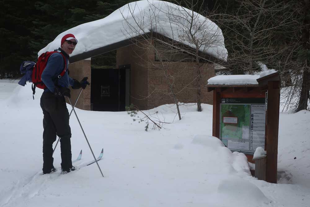
- Gary Vequist checks out the information board and bathroom at the Mount McLoughlin Trailhead.
It was a great place for a picnic.
Trending
But it wasn’t the best time of the year. The sun was shining, but the temperature was still in the 20s. And there was a small problem with the picnic table — it was layered with several inches of hard-packed snow.
Reaching the picnic spot came after three miles of uphill cross-country skiing. To handle the chill, we put on the jackets, gloves and wool hats that we’d peeled off while skiing. And by using our ski poles, we chipped openings on the picnic table where we could sit and eat.
Our setting was the Mount McLoughlin Trailhead, where the Forest Service has installed a vault toilet, information board and picnic tables. In snow-free months it’s easily reached by driving good gravel roads. Until a few years ago it was the place where people climbing McLoughlin parked and began the challenging ascent, which includes at 4,000-foot elevation gain. But the once-crumbling bridge that crossed the canal has been removed and not replaced, so hikers are now directed to instead start from the Summit Trailhead.
Trending
We — Gary Vequist and I — weren’t planning a McLoughlin climb. We had reached the trailhead by following the Lower Canal Trail Ski Trail from the Summit Sno-Park off Highway 140. The trail was somewhat icy, but a smattering of fresh snow made conditions skiable.
Reaching the McLoughlin trailhead was no picnic, and not because of the sometimes icy, slick snow or the chilly air.
Earlier that morning I had carefully placed my skis and poles in my car, made sure I had enough water and snacks, and stashed extra mittens and gloves in my daypack. I wanted to be prepared.
It wasn’t until loading my gear into the trunk of Gary’s car that — oops — I realized that I’d forgotten my ski boots.
Because it would have taken another half-hour or longer to retreat back to my house, grab those missing boots, and hustle back to Gary’s, he volunteered to loan me an extra pair of his ski boots. They were a few sizes too large, but some extra layers of socks solved that potential dilemma. But there was another problem — his boots wouldn’t fit on my ski bindings. I needed to use his boots — and skis.
But Gary is seven or eight inches taller than midget-me. His skis were longgg. Even standing on my tippy-toes while holding the skis vertically, I could barely touch the top. That would make turning challenging, especially on icy downhill sections. Then, while stepping into the right ski binding, something felt wrong. Turns out the material on the ski’s bottom layer was peeling off.
What did we do? Start skiing, of course.
From the Summit Sno-Park it’s about a quarter-mile to the Lower Canal Trail. The Lower Canal is a favorite route. Bisecting the trail as it climbs are a series of other trails — the Petunia, Powerline, South Rye, Pitt View, Big Mac and the junction with the Fourmile, Billie Creek and Cascade Canal roads. Some offer loop routes. Some connect with the northbound Pacific Crest Trail, which is also accessible from the Summit Sno-Park.
The Lower Canal Trail passes through lush stands of red cedar, hemlock and lodgepole and Ponderosa pines. The terrain varies, with mostly moderate climbs between relatively level sections. When conditions are right, that means joyful stretches of double-poling on the way back.
Despite the challenges, it was a fine ski. It’s always satisfying to be out, immersed in sights like snow-draped trees, sounds like the music of unseen birds.
Not every outing is perfect — and there are more stories that could be told of other mishaps that followed — but just enjoying nature in winter is perfectly delightful.
Marketplace

2025 Community Choice Awards

-
eEdition

-

-
