Landslide closes Rogue River National Recreation Trail
Published 1:45 pm Thursday, April 27, 2023
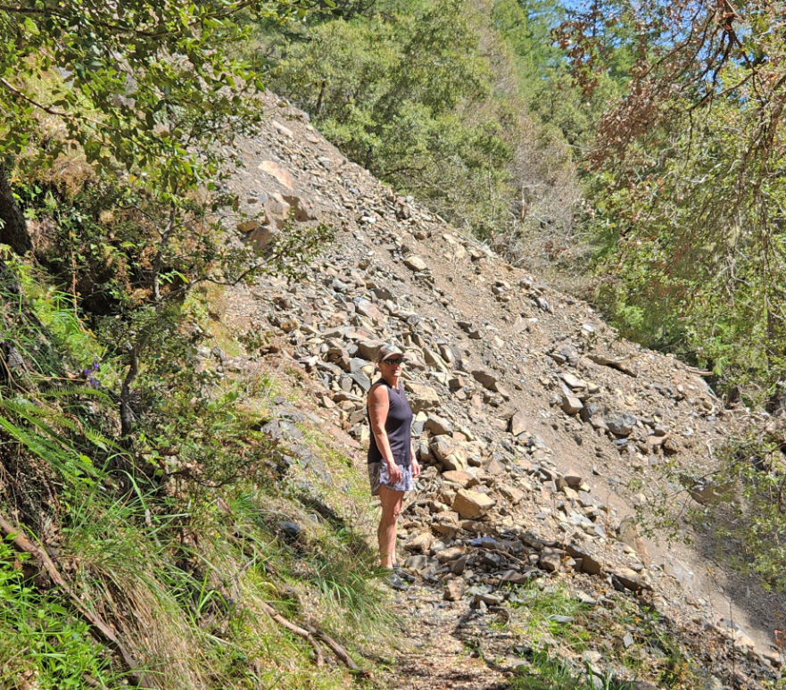
- Gina Porzio, a Bureau of Land Management river ranger, sizes up a landslide on the lower Rogue River Trail approximately one mile upriver from the Rogue River Ranch. On Monday, a BLM team composed of military veterans will start hiking 20-plus miles toward the slide with the intention of clearing it. They expect to reach it Wednesday or Thursday, clearing the trail of obstructions as they go.
The 40-mile-long Rogue River National Recreational Trail has been closed at a point about halfway down its length due to a 150-foot-wide landslide, just as peak hiking season arrives.
Trending
“We’re right around peak season,” Kyle Sullivan, spokesman for the U.S. Bureau of Land Management, said Wednesday. “It’s getting warmer out. It’s an ideal time to hike the trail.”
An ideal time, perhaps, if not for the slide, located about one mile upstream from the remote Rogue River Ranch National Historic Site, near mile 21.5 of the trail.
The trail, which is co-maintained by the BLM and U.S. Forest Service, parallels the Wild Section of the Rogue River, a federally protected Wild and Scenic river. The trail’s eastern end, at Grave Creek, is about 30 miles northwest of Grants Pass. The trail’s western end is at Big Bend, near Foster Bar and Agness, about 35 miles from the mouth of the river at Gold Beach and the Pacific Ocean.
Trending
No reopening date for the trail has been set.
“Wow, that’s bad news,” said Debbie Thomason, owner of the Galice Resort, located about seven miles upriver from the trail’s eastern end at Grave Creek. “The volume of hikers is March through mid-June and then September and October.”
Kory Mahr, operations manager for Orange Torpedo Trips of Merlin, which provides vehicle shuttle services to hikers, said three groups last weekend put off their hike because of the slide.
“It’s a bummer,” he said. “Spring and fall are sorta the core times for people to explore that trail.”
Sullivan said this weekend normally would be one of the busiest of the year for hikers. May is busy, too, before the heat of summer arrives. Temperatures in the upper 80s are predicted for nearby Merlin on Friday and Saturday.
Hikers still can take the trail as far as the landslide before turning back. Hikers who are headed downriver and supported by rafts can get around the blockage via raft.
“Raft-supported hiking trips are advised to be prepared to float their hikers around the slide area,” the BLM advised in a news release issued Wednesday. “One option would be loading hikers into rafts at Quail Creek and floating them three miles to the Rogue River Ranch. The slide is located between John’s Riffle and Maggie’s Riffle.”
The agency strongly urged hikers to avoid the area.
“The landslide has obliterated approximately 150 feet of the trail,” the news release stated. “There is no clear, safe route around or over this obstruction. The BLM has issued a public land closure for the affected area.”
According to social media postings, at least one hiker who encountered the slide said she turned back. Another person wrote that the agency had overreacted and that the crossing looked feasible, although others disagreed with him.
Mike Vanderberg, Grants Pass field manager for the BLM, urged caution.
“Traversing this active slide would expose a hiker to the possibility of injury or death,” he said, according to the news release.
Sullivan said agency personnel were at the scene Wednesday. He warned of the potential for more debris to fall. He said snow remains 8-10 feet deep in the mountains above the river and trail. Runoff from snowmelt can contribute to debris fall.
Downed trees, landslides and high water in creeks can create difficult passage along the trail during the rainy season, usually November through April. Annual maintenance usually occurs April through June, after winter storms are no longer a threat.
The trail, deep in a canyon, follows the river’s north side. Sixteen miles of it, on its western end, crosses through the Wild Rogue Wilderness. The trail follows a mostly moderate grade that skirts cliffs at times.
The trail is for hikers only. Motorized vehicles, bicycles and pack animals are not allowed. The average hiker takes four to five days to hike the trail, according to an agency trail guide.
This story has been updated to reflect that Orange Torpedo Trips of Merlin provides vehicle shuttle services.
Marketplace


2025 Community Choice Awards

-
eEdition

-

-
