Remembering the Big Bend Dam (copy)
Published 8:00 am Thursday, May 4, 2023
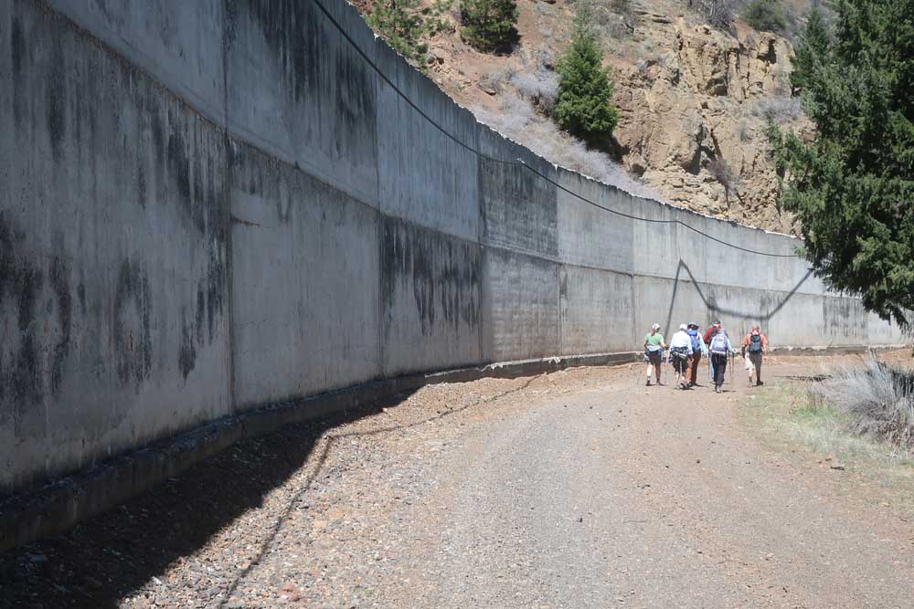
- A closed-to-motor-vehicles road allows hikers to walk along the massive concrete aqueduct.
It was a hike that offers some darn fine views of the Klamath River, but not much in the way of dam fine sights.
The dam we didn’t see from the trail was the John C. Boyle Dam. Located six miles downstream from Keno, the Boyle is one of the four Klamath River hydroelectric plants scheduled for removal. The first dam being removed is Copco 2, with its demolition planned to begin this summer, while Boyle, Copco 1 and Iron Gate are set for 2024.
The trail we took is actually a gravel road that begins just downstream from the Boyle Dam. Gated and closed to motor vehicles, the route follows alongside a massive elevated concrete aqueduct for nearly 2.5 miles that’s out of sight from the more traveled upper canal road that continues downriver to recreational sites, including the Klamath River Campground and the Spring Island launch site, the put-in spot for raucously wild whitewater raft trips. Our hike ended at the spillway, where the closed road ends.
It’s an easy, level walk that stays high above the Klamath. It’s scenic, with several overlooks peering down to the river. In some sections the Klamath flows smoothly, but in others, especially where the river bends, it explodes into a frothy brew of whitewater.
Those twisting river bends, along with a nearby section known as the Big Bend, explain how the dam got its original name. From 1958, when it was put into service, until 1962, it was the Big Bend Dam.
Plans to rename the Big Bend were revealed Feb. 3, 1962, by Pacific Power & Light Company, which had purchased the Klamath River hydroelectric dams from Copco (California Oregon Power Company). Later that year, on June 25, during rededication ceremonies, the man named John C. Boyle had a dam fine surprise. During the gathering, it was revealed the Big Bend Dam was renamed the John C. Boyle Dam and Powerhouse.
Boyle was honored because of his involvement in years of designing and building dams. Before becoming PP&L’s vice president and director for PP&L, he was superintendent of construction for Copco Dam No. 1 and, later, the Link River Dam in Klamath Falls. For decades, Boyle engineering other hydroelectric projects in the Klamath, Rogue and Umpqua river basins. In 1951 he had been named Oregon Engineer of the Year.
The Boyle Dam and Powerhouse are significant because they produce more than half of the Klamath hydroelectric project’s power and nearly four times as much power as any other Klamath River dam. The concrete canal that we hiked along carries up to 2,400 cubic feet per second of water down the Klamath River canyon and through a hillside. Farther downstream from where our hike ended, the water turns the two energy-producing turbines at the Boyle Powerhouse. Removing the Boyle Dam and Powerhouse had been opposed by some because of the power it produces and because, unlike the other dams being removed, it has a fish ladder. The dam and powerhouse, however, do not produce flood control or irrigation water.
We wandered around the spillway structures and an overlook with views of the seriously steep spillway, which has draped cable nets to stabilize the canyon wall, before doubling back to our vehicles that we had parked in a field outside the gate. Earlier, hike organizer Hans Kuhr showed us a section along the aqueduct where a massive 2005 rockslide seriously damaged the concrete aqueduct.
There are more scenic ways to see the Boyle Dam, such as by kayaking downstream from either of two easily accessed put-in spots in the Topsy Reservoir just off Highway 66. But our hike provided other, very different, less often seen perspectives. The views from the trail impress the depth of the Klamath River Canyon and, more unusually, the size and scale of the water-transporting aqueduct and spillway.
Just like John C. Boyle, we were damned well impressed.


2025 Community Choice Awards

-
-
-