Trail crew heads off on annual trek to clear the trans-Kalmiopsis route
Published 9:10 am Friday, May 26, 2023
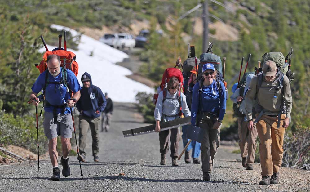
- Siskiyou Mountain Club members begin their annual trek through the Kalmiopsis Wilderness Area Wednesday.
A crew of six hardy hikers with the Ashland-based Siskiyou Mountain Club set off early Wednesday on what has become an annual tradition to clear brush and downed trees on trails leading across the remote Kalmiopsis Wilderness of western Josephine County and eastern Curry County.
The crew started its trek from a top-of-the-world trailhead near Babyfoot Lake, located in coastal mountains about 10 miles northwest of Cave Junction. The group planned to follow a 27-mile route to the Chetco River and beyond, ending on Memorial Day at Vulcan Lake, about 20 miles northeast of Brookings, where they would meet a shuttle van and return to the Rogue Valley.
SMC started here
The route they were following, dubbed the trans-Kalmiopsis route, uses portions of seven trails that the club began clearing in 2010 in the wake of the 2002 Biscuit Fire.
Returning year after year on annual treks and at other times, club members and volunteers took five years to clear the route through downed trees, heavy brush and across rough terrain.
“It’s a real special one,” crew leader Karly White of Medford said, referring to the route across the wilderness.
“It’s the first route the SMC adopted back in 2010,” said Gabe Howe, executive director of the club, which has grown from a handful of volunteers into a nonprofit organization with hired staff, interns and volunteers who maintain miles of trails in the region.
The annual hike across the Kalmiopsis is part tradition, part work party and part staff training, according to Howe, who characterized the trek as a great backpacking outing that appeals to the “adventuresome and intrepid.”
“It’s an amazing trail,” he said.
You have to be in great shape
White, her fellow hikers and Howe arrived by shuttle van shortly before 9 a.m. at the trailhead, stopping a few hundred feet short of a parking area because the road was blocked by snow a few feet deep. A cold wind blew as the crew unloaded its gear, which included hand tools, hard hats and large backpacks, the heaviest weighing in at 80 pounds fully loaded.
Among the tools were chopping, shoveling and cutting implements, including a manually operated crosscut saw. Chain saw use is prohibited in the wilderness.
A requirement of participants is that they be in great physical shape and have strong, recent backpacking experience. All were vetted by White.
Plans for the day’s work included a trek of about six miles to the Bailey Mountain area, with most of the work to be concentrated on a nine-mile stretch of trail beyond that, to Taggarts Bar on the Chetco River.
The topography of the entire route would take the hikers down off the ridge to the river before climbing out to high ground beyond. Temperatures were expected to reach up into the 70s and down into the 50s.
“Everybody ready?” White said at one point, after crew members had lashed their tools onto their packs. White then gathered the group and went over safety reminders: Hard hats must be worn at all times while working. Don’t stand under a big dead tree when the wind is blowing hard. Handle tools with care. Hydrate. If you get lost, stay put. Don’t feed the animals. Give rattlesnakes a wide berth. Watch out for poison oak. Beware of ticks.
If an emergency arises, club staff member Nick Hodges of Gold Hill was designated to be lead responder. Hodges carried with him a device capable of sending text messages via satellite. He would use it to check in nightly with home base.
In the group were three staff members and three volunteers.
“I hope I hold up,” said volunteer Dan Burdis of Grants Pass, who had shown he could hold up during past outings.
Volunteer Luke Brandy of Ashland, a professional forester, was making the trek for the ninth year in a row.
“I keep coming back,” he said. “It’s great to see it change and recover … and burn again.”
“I love the botany. I love to see the rare plants.”
Fire prone wilderness
The Biscuit Fire burned about 500,000 acres of terrain in and around the wilderness area in 2002, while the Chetco Bar Fire 15 years later burned nearly 200,000 acres, much of it through the wilderness, followed in 2018 by the Klondike and Taylor Creek fires, which burned a combined 229,000 acres, much of it in the Biscuit Fire footprint.
Howe, who was staying behind, wished them well. Rounding out the crew were Nate Chotlos, a volunteer from Medford, and Lucy Gallagher of Gold Hill, a staff member who was making the trek for the first time.
“It’s a transformative type of experience,” Howe told the crew. “Listen to Nick. Listen to Karly. Do what they say. Don’t get lost. If you do, stay where you are. Enjoy the river.”
The snow was so heavy this year, it was uncertain whether the annual hike would happen, but the ground Wednesday was mostly bare.
“Everything is right with the world,” White told the group. “Let’s go get it done.”
The crew, weighed down with packs, stood patiently for a group picture and club video before moving out down trails that Howe described as primitive.
“This isn’t your grandma’s cup of tea,” he said.
The trail initially headed up a slight grade before rounding a corner and dropping down into an eerie landscape of brush and standing dead trees. To one side of the trail for a few hundred feet was a steep drop that surely would mean injury or death if someone slipped. In spots, the trail surface was maybe 18 inches wide and topped by loose gravel. Footing was tricky.
The group soon disappeared into the wild.
The Kalmiopsis was a disaster
The Kalmiopsis, which was designated a wilderness in 1964 by Congress, takes in about 283 square miles of terrain in an area that stretches from near the Rogue River on the north to the California border on the south. It includes portions of the Illinois River and the headwaters of the Chetco River and North Fork Smith River.
The club has six field staff members, plus 21 interns and about 50 volunteers. It was formed in 2010, but has its roots going back to 2005, when Howe and his wife, Jillian Stokes, hiked the burned-over wilderness and lamented the neglected state of its trails.
“The trails were just falling apart,” Howe said. “Just a disaster.”
As time went on, and little changed, he began making inquiries of the U.S. Forest Service, which has jurisdiction in the area.
“We were asking, ‘What’s the plan?’” Howe recalled. “The answer was, ‘Nothing.’ It was just a total apathetic sense that had permeated these stakeholders.”
Howe eventually proposed that volunteers clear the trail starting near Babyfoot Lake, and signed a volunteer agreement two days before that inaugural work party set out June 8, 2010. He remembers that the agency lent them an “old rusty crosscut saw” and some radios.
Howe still has a photo that shows that first work crew at the trailhead. Seven people are in the picture, including his wife and his father, Lee. They actually went out a couple times that year.
“We haven’t looked back,” he said.
Five years later, after sometimes-grueling work, the trans-Kalmiopsis route was cleared.
“Year by year, we were coming in from both sides,” Howe said. “We finally cut the ribbon in 2014.”
To clear the route, an estimated 20,000 downed trees that had fallen across the trails were cut, according to Howe. Crews encountered thick brush that grew back quickly.
“You crawl along on your hands and knees, cutting,” Howe said. “We were young. We were in our 20s. And we were tough.”
‘A significant accomplishment’
The club has now grown to the point that its budget this year is about $600,000, with roughly half of that coming from contracts with the Forest Service and the rest from donations, investments and merchandise sales at the club’s outdoors store in Ashland. Club staff members and volunteers currently help maintain about a third of the trail inventory in the Rogue River-Siskiyou National Forest, including the Rogue River National Recreation Trail downriver from Galice, the Illinois River Trail downriver from Selma and the Upper Rogue River Trail upriver from Prospect. The club’s efforts extend to other wilderness areas in other forests.
Virginia Gibbons, USFS spokesperson, said in a telephone interview that the work of the club has been pivotal.
“They have been a great partner,” she said. “They are passionate about getting that work done, even though we don’t have a big budget to get that done.”
She said the club had to cut through burned downed trees in the Kalmiopsis that had fallen across trails in a haphazard pattern that she called “jackstraw.”
“It was a tremendous amount of work,” she said. “It was a significant accomplishment.”
“If we hadn’t partnered with them, my guess is those trails would not be open today.”
While other community groups and volunteer organizations help maintain trails across the forest, the Siskiyou Mountain Club is the primary group doing such work.
“They have had a broad influence over the forest,” Gibbons said. “They have been working hard for years on this forest.”
Howe said the work of the club honors trail builders of the past, including the Depression-era Civilian Conservation Corps.
“People worked hard before us to build those trails,” he said, adding that he wants to “maintain that spirit.”
A trail across the wilderness
The trans-Kalmiopsis route is a series of seven rugged trails that cross the remote Kalmiopsis Wilderness of western Josephine County and eastern Curry County.
The route is maintained by the nonprofit Siskiyou Mountain Club, which has produced detailed maps of the area, sold online and at the organization’s Siskiyou Outdoor Store, 33 N. Third St. in Ashland.
The seven trails and their U.S. Forest Service designated numbers are Babyfoot Lake (1124A), Babyfoot Lake Rim (1126), Kalmiopsis Rim (1124), Emily Cabin (1129), Bailey Cabin (1131), Bailey Mountain (1109), Upper Chetco (1102) and Johnson Butte (1110).
The eastern terminus of the route is at the Babyfoot Lake Trailhead, located about 10 air miles northwest of Cave Junction. The lake, reached via trail, is about a mile west of the trailhead, which is reached via dirt-and-gravel forest roads that should not be attempted without proper preparation.
To reach the trailhead, take Highway 199, the Redwood Highway, from Grants Pass about 24 miles to Eight Dollar Mountain Road/USFS Road 4201, then go west on the road for about 14.5 miles to Forest Road 140, and continue on Forest Road 140 south to the trailhead.
More Outdoors


2025 Community Choice Awards

-
-
-