West Swan Lake is just as wet as we remembered
Published 9:15 am Wednesday, August 23, 2023
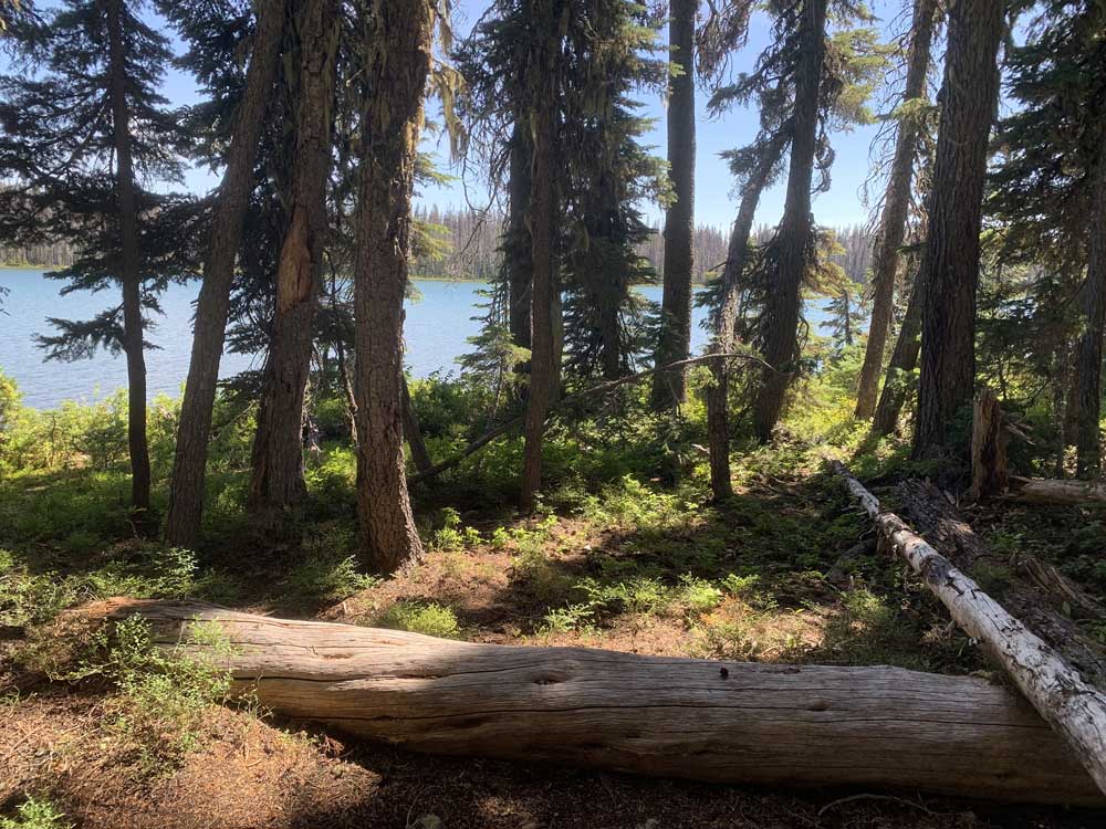
- West Swan Lake, seen through the trees, is full of water.
The report had been ominous. West Swan Lake in the Sky Lakes Wilderness was little more than a large swampy bog, we’d been told.
Trending
A veteran hiker/backpacker who had been to the lake a few days earlier reported she had “found the water level very low and could not find the campsite we have used in the past.”
So when our group of hikers reached the “lake,” which is located off the Twin Ponds Trail and was just planned as stopover on a longer hike to Summit Lake, we were shocked and numb to find a mostly marshy, obviously shallow body of water. Two of the group who had camped at the lake in previous years wandered aimlessly searching for their lost campsite.
After meandering along its murky shores, we returned to the trail to resume our trek toward the trail’s junction with the Pacific Crest Trail on our way to Summit Lake.
Trending
Surprise! Less than a quarter-mile up the trail, double-takes were universal. Appearing like a mirage alongside the trail and visible through the trees was a beautiful, very large, very full, very blue West Swan Lake — which is still known on Forest Service maps as Squaw Lake in spite of a recent name change.
It turns out the lake our scout thought was West Swan wasn’t, and wasn’t even wasn’t a lake. Instead, we realized, we had been at — oops! — Norris Pond.
Everyone perked up. We veered off the trail, found those remembered, truly alluring campsites. We wandered along the shoreline and wet meadows, admiring the varieties of wildflowers and, although rows of lodgepole pine along the opposite shore had been blackened by recent forest fires, were stunned by the expanses of tall trees. Spring rains combined with last winter’s vigorous snowfall had obviously helped keep the lake full and beautifully blue.
Trip leader Bill Van Moorhen pointed out a section of the historic 1864 Fort Klamath-Jacksonville Military Wagon Road, also known as the Rancheria Trail. Built in 1863, for many years it connected the Rogue Basin with the Upper Klamath Basin, including the former Army fort at Fort Klamath.
When we returned to the trail — after marking one of the lake access points with a rock cairn — hiking conditions improved. Earlier on the hike in, about a mile from our starting point at the Fourmile Lake campground, sections of the trail were blocked with fallen trees. Some we climbed or stepped over. One we limbo-stooped under. Others we detoured around. Surprisingly. and delightfully, as we headed north to the PCT, where it leaves the Fremont-Winema National Forest and becomes the Rogue-Siskiyou National Forest, the obstacles disappeared.
Obstacles aside, the Twin Lakes Trail is a gentle, family-friendly hike with gently rolling terrain and minimal elevation gains over its three-plus miles to Summit Lake, which like West Swan Lake was along part of the historic Fort Klamath-Jacksonville Military Wagon Road. From the lake, the trail continues another three-plus-miles to the actual Twin Ponds, described as “two shallow, snow-melt ponds of nearly identical size and shape located within 50 feet of each other.”
On our way to Summit Lake, at the PCT junction we passed alongside a resting PCT thru-hiker. She was nearly hidden, flopped-out and lying in a shady spot on the ground. Some thru-hikers are eager for conversation, but she was content with a weary and brief, “Hello.”
We halted for lunch at Summit Lake. Along with what we carried in our packs, we nibbled the relatively few ripe huckleberries. Rested, and with full bellies, we doubled back to the Fourmile Lake campground. At the PCT junction the backpacker was gone, back on the trail.
Trails seem “different” when hiked in reverse. Forests of tall mountain hemlocks and Shasta red firs seemed even more distinct and abundant. Patches of fireweed and penstemon seemed more prolific. And West Swan Lake appeared even bluer.
As we neared the trailhead, “What,” someone asked, “is the significance of the name Fourmile?” According to Jeff LaLande, in “From Abbott Butte to Zimmerman Burn: A Place Name History and Gazetteer of the Rogue River National Forest,” the name was given about 1860 “due to mistaken belief by Rogue Valley settlers that the lake was four miles long. It is less than three miles …”
Historically and in present times we all make mistakes, whether about the length of a lake, or thinking a pond is a lake.
The Twin Ponds trailhead is accessed from the Fourmile Lake campground. To get there from Medford, take Highway 140 past the Fish Lake turnoff to Forest Road 3661, which has a sign for Fourmile Lake, and turn north (left). Continue up the road nearly 6 miles to the Fourmile Lake Campground and follow signs to the parking area/trailhead. There is no day-use fee.
Marketplace


2025 Community Choice Awards

-
eEdition

-

-
