OUTDOOR ADVENTURES: New Ashland park benches; Table Rock trail work; Christmas tree permits
Published 9:45 am Wednesday, November 15, 2023
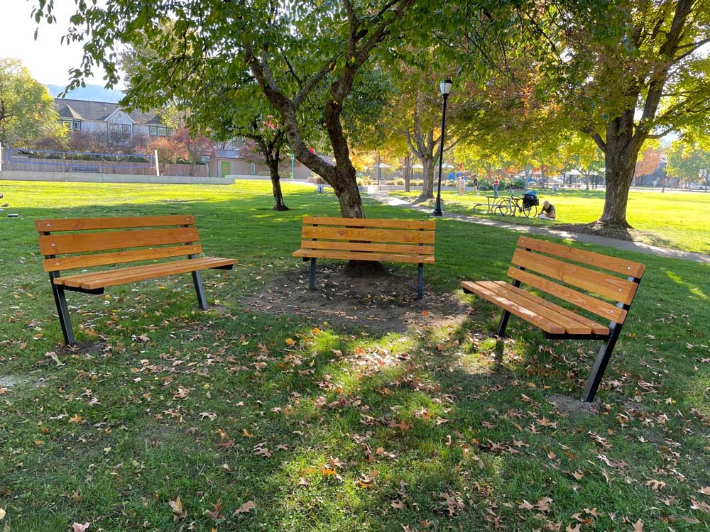
- These benches at Garfield Park in Ashland are part of a demonstration project called "Conversation Clusters" that make use of benches and seats that face each other. The public is asked to check them out, as well as other seats in Lithia Park and Glenwood Park.
The city of Ashland is inviting the public to try out and comment on new park seating arrangements known as “conversation clusters.”
Trending
The seating arrangements, part of a demonstration project, allow users to face one another, in contrast to the usual arrangement of benches facing outward toward a more distant view.
“Face-to-face conversations provide more engagement,” said Anne Bellegia, co-chair of the Liveable Ashland Alliance.
The city is testing three different arrangements in three parks:
Trending
• In Lithia Park, on the lower lawn facing Winburn Way, park users may move around a set of 20 stacking chairs.
• In Garfield Park, at East Main and California streets, a semi-circle of three fixed benches face a view of Grizzly Peak.
• In Glenwood Park, at Glenwood Drive and Ashland St., a circle of four fixed benches are near the center of the park.
Leslie Eldridge, interim parks director, said the moveable chairs in Lithia Park are the biggest challenge.
“We are trusting the community to use the chairs there and leave them for other park users to enjoy,” she said. “However, if people remove the chairs from the park or move them to other locations, we won’t be able to replace them.”
As of last week, the chairs were still in place, according to Isleen Glatt, senior services superintendent for the city, which announced the arrangements Oct. 30 and asked the public to comment via a survey once they had visited one or more of the locations.
“We’ve had a lot of positive verbal comments so far, but only a few survey responses so far,” Glatt said. “I will be sharing the survey results after the survey closes.”
Comments are being taken through Dec. 17. Go to surveymonkey.com/r/ConversationClusters or call 541-488-5342 to request a survey.
Hike longer, flatter Upper Table Rock trail
The U.S. Bureau of Land Management has reopened the trail at Upper Table Rock after a month’s worth of work that resulted in some trail sections that are now less steep and a quarter mile longer. The trail to the top is now 1½ miles long.
Workers used a small tracked vehicle to haul in a significant amount of gravel — the equivalent of about 15 dump truck loads — and place it on the trail in order to help reduce erosion and mud.
“Upper Table Rock is an important area for many people around the valley,” Jared Nichol, Butte Falls field manager for the BLM, said, according to an agency announcement. “We are excited to be able to provide a safer, more enjoyable experience — with some new views!”
Funding for the work was provided through the Secure Rural Schools Act and authorized by the Western Oregon Resource Advisory Committee.
To get to the trailhead, drive north from Medford on Table Rock Road, turn right on Modoc Road and continue for 1 mile to the trailhead.
Cut a Christmas tree, help thin the forest
The public may now obtain permits to cut personal-use Christmas trees on federal forest land, according to the U.S. Bureau of Land Management. The permits cost $5 per tree, but are free for fourth-graders who complete an online activity at everykidoutdoors.gov.
Permits can be purchased online and at BLM and U.S. Forest Service offices, along with participating local businesses. To buy online, go to forestproducts.blm.gov or recreation.gov. Free maps are available showing where trees may be cut. Digital maps are available at go.usa.gov/xeDWs.
Trees that are cut on BLM land must be less than 12 feet tall, within 12 feet of another tree and leave behind a stump of a foot or less. They may not be cut within 200 feet of highways, campgrounds or developed areas.
By cutting trees, people are helping to thin densely populated stands of small-diameter trees, contributing to overall forest health, according to the agency.
On U.S. Forest Service land, people are not allowed to cut trees within 300 feet of streams and bodies of water or within 150 feet of highways, picnic areas, campgrounds or developed areas. They also may not cut trees within sno-parks, wilderness areas, wild and scenic corridors, national monuments, research natural areas, areas of critical environmental concern and developed recreation areas. They also may not cut within active timber sales or areas planted with new trees.
Trees cut on Forest Service land may not exceed 12 feet in height and stumps may not exceed one foot in height, although the agency doesn’t require another tree to be within 12 feet. People should cut down the entire tree and take the whole tree.
People should be prepared for adverse weather and road conditions. They are advised to carry tire chains, a shovel and flashlights, along with a first aid kit, water and food. They should wear gloves and boots and bring a saw and a rope to tie down cut trees.
Help remove wildlife-unfriendly fencing at Rogue River Preserve
The Southern Oregon Land Conservancy is seeking volunteers to help remove farm fencing at the Rogue River Preserve near Eagle Point on Nov. 22 or Dec. 13.
Work parties recently removed 1,000 feet of fencing at the preserve, which can be dangerous to wildlife. One of the parties found a dead deer entangled in fencing. A perimeter fence will be replaced with a wildlife-friendly fence.
Those interested in helping out may contact kristi@landconserve.org. Contact the conservancy at 541-482-3069.
Take a hike, learn about conifers in the monument
Learn about conifers and shrubs during a Dec. 2 hike led by naturalist and biology teacher Nolan Richard and hosted by the Friends in the Cascade-Siskiyou National Monument.
Participants will learn how to identify native species, where to find them and how they adapt. Conifers typically have needles, seeds and cones.
Richard, who has taught classes for the Native Plant Society, has a keen interest in plant biogeography — where and why plants locate in certain areas.
The area to be hiked is to be determined, depending on the weather. The outing is scheduled for 9 a.m. to 2 p.m. Participants will meet at the Rite Aid in Ashland, 2341 Ashland St., and leave from there. Carpooling is optional. Register for the hike at cascadesiskiyou.org. Call 541-378-3039 for more information.
The mission of the Friends group is to protect, restore and conserve the monument. The group’s goal is to introduce the public to monument places and related topics of interest.
Dance the snow dance at Mt. Ashland Ski Area open house
Mt. Ashland Ski Area is hosting a winter kickoff open house from noon to 4 p.m. Dec. 2, with live music, wine tasting and displays of a Mercy Flights helicopter and two new snowcats.
The event is free. Food and drink is available for purchase, although wine tasting by Naumes Suncrest Wineries is free.
SWS Mountain Guides will be on hand for information about avalanche and mountain safety. Plans for the new Lithia chairlift are expected to be on display. Information about what’s new will be available. New this year is Saturday night skiing, in addition to night skiing on Thursdays and Fridays. Twilight season passes are available.
The ski season opens Dec. 9. Abigail Combs, marketing coordinator for the ski area, said the lodge on Tuesday had a trace of snow.
“I think we’re going to be getting some in the next week, but it hasn’t accumulated yet,” she said. “It’s definitely getting chillier at the top of the mountain.”
“There’s a little bit of snow and it’s snowing right now, but I do believe there’s snow in the forecast. I’m doing my snow dance.”
View new map of handicapped-accessible features at BLM sites
The Bureau of Land Management has launched an online “accessibility map” to assist people with mobility issues and other disabilities. It shows accessible recreational facilities across multiple states.
A team of recreation planners, global information system data experts, communications staff, website content coordinators and writer-editors worked on the map, which launched last month.
“With valuable assistance from the field, the team is also incorporating photos and detailed information about accessible features of individual facilities, starting with campgrounds and visitor centers,” the agency announced last week. “These descriptions indicate, for example, whether service dogs are allowed; whether accessible parking, toilets, and picnic tables are available; whether campground surfaces, boat ramps, and other areas can accommodate wheelchair users; and more.”
The team consulted with National Park Service and Bureau of Reclamation accessibility specialists. It distributed a survey to colleagues in the field to validate existing data. The team intends to add further information as work on the project continues.
“It is imperative for the Bureau to improve accessibility on public lands, to ensure that inclusiveness and equity go hand in hand with ‘recreation for all,’” said Tom Heinlein, assistant director of National Conservation Lands and Community Partnerships.”
To view the map, search online for “BLM Accessibility Program.”
Readers and event organizers are encouraged to send details about upcoming outings and outdoor-related events to Rogue Valley Times outdoors reporter Shaun Hall at shall@rv-times.com or 2 East Main St., Medford OR 97501. Brief, to-the-point descriptions are best. Photographs can be helpful.
Marketplace


2025 Community Choice Awards

-
eEdition

-

-
