OUTDOOR NOTEBOOK: Trip plans in snow, scenic byway update and forest plan changes
Published 11:00 am Friday, January 19, 2024
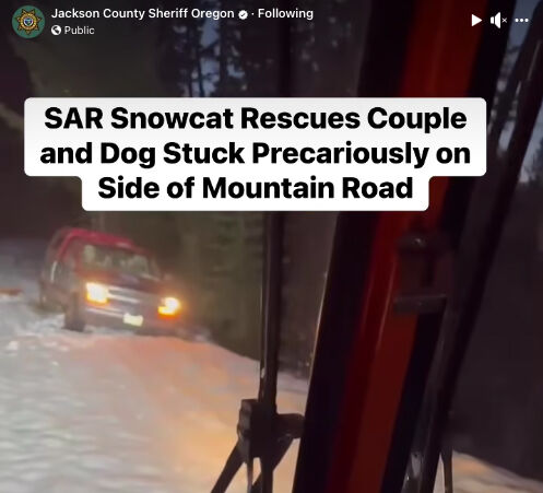
- A couple in a stuck car on the edge of a mountain road await the approach of a snowcat from the Jackson County Sheriff's Office on Monday. The sheriff's office is urging people to use a new online service to file their trip plans ahead of time, so authorities know quickly where to look, in case of emergency.
In the wake of a snow rescue on Monday, the Jackson County Sheriff’s Office is encouraging the public to use a computer application called “Share My Trip” so that people can input their trip plans and thus be more easily located and rescued if need be.
Trending
If someone is late returning for a trip and has entered trip information ahead of time, that information can speed rescuers, according to Aaron Lewis, sheriff’s office spokesman.
“At least we know where you were planning on going,” Lewis said Thursday, after posting information about the rescue. “We’re not just starting from scratch.”
“Time is of the essence when you’re looking for somebody, especially in the wintertime.”
Trending
The service, developed specially for the sheriff’s office, has been available since August. Lewis mentioned it in connection with a video he posted to the sheriff’s office social media page showing a snowcat making its way through the snow to a car stuck on the edge of remote Heppsie Mountain Road, east of Eagle Point.
In the car was a couple that had called authorities about 3 p.m. Monday to say they had tried for two hours to dig out. However, the call was brief and reception was poor, so their exact location could not be determined. In response, deputies, an aircraft and a snow-response team headed that way.
The couple and their dog were found at 5:38 p.m., as darkness was settling in. They had been headed to a cabin and had plenty of food and about half a tank of gas, according to Lewis.
“If you are venturing out into the mountains during the winter months make sure you have a full tank, charged cell phone battery, warm clothes, and plenty of food and water in case you get stuck,” Lewis stated in the posting. “Also, notify someone of your route and when they can expect you to return.”
Scenic Byway bike/pedestrian plan to be discussed
The public is invited to attend an online presentation from noon to 1 p.m. Tuesday, Jan. 23, about a proposed master plan for pedestrian and bicycle transportation facilities along the 172-mile Rogue-Umpqua National Scenic Byway.
The byway is a series of highways — 234 (Sams Valley Highway), 62 (Crater Lake Highway), 230 and 138 (North Umpqua Highway) — stretching from Gold Hill to Roseburg, via the Crater Lake area.
The plan is under development in cooperation with the Oregon Department of Transportation, U.S. Forest Service, U.S. Bureau of Land Management and the Federal Highway Administration.
The work to develop a plan includes documenting existing conditions, collecting travel data for major recreation sites and developing conceptual designs and construction cost estimates for improvements. Upcoming work includes identifying needs and opportunities.
Tuesday’s presentation will re-introduce the project, present findings to date and outline work to be done in 2024. There will be time for questions and discussion.
“More importantly, we want to hear what you think, how you would like to engage in 2024, and how you would like to be engaged in 2024,” said Cole Grisham, a transportation planner with the Federal Highway Administration, according to a meeting announcement.
To attend the webinar, go to bit.ly/43xNyLS. Reach Grisham at 202-839-1409.
Northwest Forest Plan changes to be discussed
The U.S. Forest Service has scheduled a series of webinars and a virtual open house to explain proposed changes to its landmark 1994 Northwest Forest Plan. The agency wants to focus on wildfires, climate change and preservation of mature forest ecosystems, among other issues.
The online presentations are set for 1 to 2:30 p.m. Saturday, Jan 20; 10 to 11:30 Tuesday, Jan. 23 and 12 to 1:30 p.m. Thursday, Jan. 25. The open house is 5 to 7 p.m. Feb. 8.
A key feature of the 1994 plan was the creation of reserves that generally prohibited logging on forests over 80 years old, thus allowing those areas to recover from past logging. It was established to address threats to threatened and endangered species.
The plan covers 24.5 million acres of federally managed lands in western Oregon, western Washington and northwestern California, including the Umpqua, Klamath and Rogue River-Siskiyou national forests.
The public may formally comment on current proposals through Feb. 2, with an additional comment period following the completion of a draft environmental impact statement.
To learn more or attend one of the presentations, go to fs.usda.gov/r6. Reach the supervisor’s office of the Rogue River-Siskiyou National Forest at 541-618-2200.
Marketplace


2025 Community Choice Awards

-
eEdition

-

-
