OUTDOORS NOTEBOOK: Big quake of 1700, wildlife center update, bike-hike plan and more
Published 2:30 pm Thursday, February 8, 2024
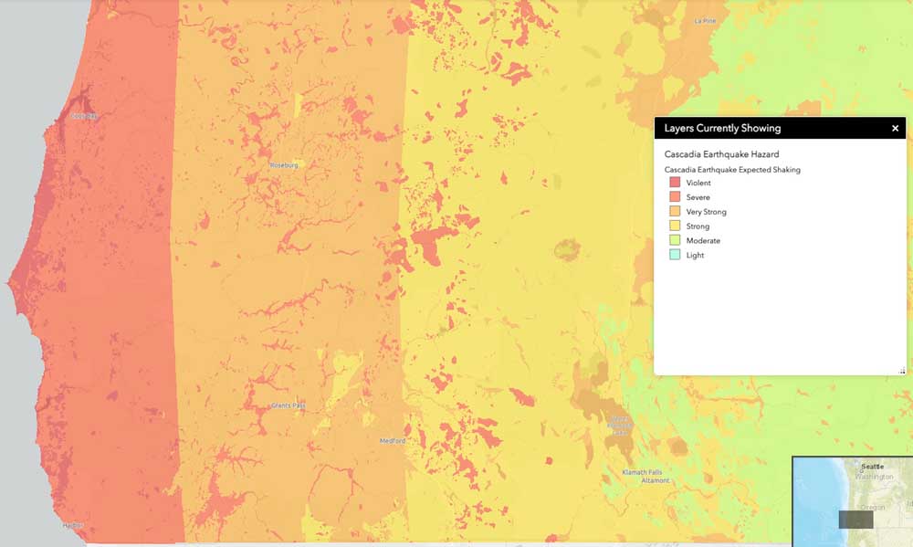
- The degree of shaking that could take place when the next Cascadia Subduction Zone earthquake hits is depicted in this image taken from an interactive online map provided by the Oregon Department of Geology and Mineral Industries. Hardest hit would be areas shown in red, closest to the Oregon Coast.
A couple of weeks ago, geology hazard specialist Lalo Guerrero and his colleagues at the Oregon Department of Geology and Mineral Industries issued a warning wrapped in a mystery.
Trending
“Around 9 p.m. on Jan. 26, 1700, a powerful magnitude 9.0 earthquake struck along the Cascadia Subduction Zone,” they wrote in a news release that described the sudden movement of the earth’s tectonic plates off the coast of the Pacific Northwest on that day more than 300 years ago. “This earthquake released energy equivalent to about two billion tons of TNT, leading to significant impacts along the Oregon coast, the effects of which are preserved in the oral traditions of native communities and evident in the landscape.”
The authors described intense shaking and tsunami waves that would have followed such a quake, but they quickly moved on to warn readers that pent-up energy has been building since then and that people should be prepared. They offered several pieces of advice, but left hanging additional details about how they knew the time and day of an event so long ago.
Guerrero, in a telephone interview on Wednesday, provided those details.
Trending
“It’s part of a really interesting story,” he said.
It turns out that a Japanese researcher studying harbormaster and shipping records in the 1990s came upon descriptions of a tsunami that struck Japan without warning on that date long ago in 1700. But the locals, according to the records, couldn’t explain the source of the waves. They knew of no local earthquake that preceded it that would cause the tsunami, which became known as an “orphan tsunami.”
Only when that research in Japan was paired with research in the United States about the last Cascadia quake was the mystery solved. Findings were published in 2005 by author and researcher Brian Atwater, in cooperation with the Japanese researcher, Kenji Satake, and others.
“He was trying to identify the source of the earthquake,” Guerrero said of Satake.
The research in America included oral histories of Native Americans, sediment deposits and so-called ghost forests of drowned trees in the Pacific Northwest, according to an article published by the National Atmospheric and Oceanic Administration, bit.ly/3uAUk7Q.
“By comparing the tree rings of dead trees with those still living they could tell when the last of these great earthquakes struck the region,” the agency states. “The trees all died in the winter of 1699-1700,” when the coasts of northern California, Oregon and Washington suddenly dropped about 3-7 feet, flooding them with seawater. “That much motion over such a large area requires a very large earthquake to explain it — perhaps as large as 9.2 magnitude.”
Severe shaking could have lasted five minutes or longer, according to NOAA.
“Its tsunami would cross the Pacific Ocean and reach Japan in about 9 hours, so the earthquake must have occurred around 9:00 at night in Cascadia on Jan. 26, 1700,” the agency stated.
Back to the news release, which served as a reminder that earthquakes happen, Guererro and his associates advised the following:
• Prepare for the next earthquake by keeping two weeks worth of supplies on hand.
• If an earthquake strikes, drop and hold on.
• After the shaking stops, evacuate quickly to higher ground, if in a tsunami zone.
• Sign up for ShakeAlert, an early-alert system that sends notifications about earthquakes to mobile devices.
For more information on preparedness, go to the Oregon Office of Emergency Management, bit.ly/3SvrEFw. To sign up for earthquake alerts, go to shakealert.org.
Wildlife Images rehab center delays reopening
Wildlife Images Rehabilitation and Education Center near Grants Pass has delayed its planned reopening to the public until an unspecified time this spring.
The center, which typically is open for public tours, announced on Dec. 11 that it was closing to the public until Feb. 2 because of “a sudden and significant change in staffing.”
Last week, the center issued an update:
“Over the last few months, we’ve been working on some very exciting large-scale improvement projects and onboarding new staff,” the organization said in a social media post. “However, timelines are taking longer than we originally anticipated.”
New projects include renovating animal enclosures to make them more natural, building a new eagle enclosure and building a new cafe, according to the statement. Other projects include gift shop and restroom renovations, a new website and installation of Wi-Fi donated by the Josephine County Board of Commissioners.
Details about how many staffers left to prompt the closure have not been made public by the center, which has hired a new operations director. A message left for center director Dave Siddon Jr. was not immediately returned Thursday. Though closed to the public, the center is continuing to care for animals.
Scenic byway bike-hike plan in the works
The team working on a master plan for bicycle and pedestrian facilities along the Rogue-Umpqua Scenic Byway in northeastern Jackson County and eastern Douglas County has produced several informational reports, including one looking at existing conditions. Next up is creation of a “needs list.”
Among the items under consideration are bike paths, bike lanes and pedestrian safety measures. The purpose of the plan is to identify ways to better meet the needs of recreational users accessing recreation sites along the byway.
The federally designated byway is a series of four connected rural highways — 230, 234, 62 and 138 — that run from Gold Hill to Roseburg via the Diamond Lake and Crater Lake areas. The route is shaped somewhat like a backward C. Meetings to gather public input have been held in person and online in the last year, including last month.
“The project team is building the universe of project needs by corridor segment now and hope to have a draft needs list posted later this month,” Cole Grisham, a project manager with the Federal Highway Administration, said in an email on Monday. “The needs reflect what we heard through public and stakeholder engagement, data collection, and existing conditions research and are not prioritized in any way.”
The public will be asked for additional comment and suggestions about where to focus efforts, he said. After that, a final report will be put together by year’s end that outlines concept design, cost estimating and management issues.
Master plan project team managers include personnel from the highway administration, the Oregon Department of Transportation and the U.S. Forest Service. The project is formally known as the Rogue-Umpqua Bicycle and Pedestrian Corridor Plan.
Thus far, the project has published a 73-page memo on existing conditions, a 40-page analysis and a 25-slide presentation from last month’s online meeting. View them on the plan’s project page, bit.ly/43xNyLS. More information is available from Grisham at 202-839-1409.
Marketplace


2025 Community Choice Awards

-
eEdition

-

-
