‘It’s just magical’: Hiking Table Rocks provides inspiration and awe
Published 10:30 am Saturday, April 27, 2024
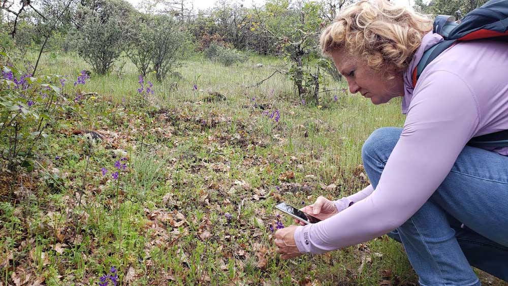
- Alisa Sawich of Medford checks out flowers during an April 18 guided hike at Upper Table Rock. For the 38th year, the U.S. Bureau of Land Management and The Nature Conservancy are offering free guided hikes at the Table Rocks, through June 1.
The wildflowers are blooming at the much-loved Table Rocks, and a long section of new, easier trail built at Upper Table Rock is all the more reason to explore them.
A moderately strenuous hike of about an hour takes visitors to the top of the formations, which rise about 800 feet above the valley floor. Located about 10 miles north of downtown Medford, the views are spectacular.
Visitors may hike the Table Rocks at their leisure or take one of the guided hikes hosted this time of year by the U.S. Bureau of Land Management and The Nature Conservancy, which jointly manage the land.
More than 60,000 people a year visit the Table Rocks, according to Molly Allen, an education specialist with the BLM. Visitors are encouraged to avoid picking flowers because if each visitor picks one, it adds up.
“One flower may not seem like a big deal,” Allen said during a mid-April hike that she helped lead at Upper Table Rock. ”It becomes a big deal.”
Take only pictures and leave only footprints — and leave those on the trail if you want to avoid poison oak.
Sofie Maciel, a volunteer who assisted with the hike, told the 17 or so visitors along on the hike that indigenous people considered the Table Rocks sacred.
“It’s something to keep in mind as we hike today,” she said. “It’s just magical.”
Among the wildflowers in bloom that day were camas, rare dwarf woolly meadowfoam and cat’s ear, so-called because of its fine hair-like features.
“It looks fuzzy, like a cat’s ear,” said Chamise Kramer, a U.S. Forest Service graphics team leader and a botanist who helped to lead the hike.
“If you come up here in a couple weeks, it’ll be a sea of flowers,” Kramer said.
Camas, which has a bulb that served as food for indigenous people, features a purple bloom that looks like a tiny exploding firework.
“It’s so gorgeous,” Allen said. “I love them.”
“This is going to be an amazing camas meadow in a few weeks,” she said at one point.
The first two-thirds of the trail at Upper Table Rock are easier than the last third. From the trailhead, the trail ascends several hundred feet to a monolith rock, after which the newly reconstructed part of the trail — nice and wide and graveled — extends until becoming noticeably steeper for about the last third of the journey, where footing can be tricky in spots.
Along the way are oaks, many of them hundreds of years old, even though they might look small and scraggly. They are fire-adapted to the region.
“Oaks have this thick bark,” Allen said. “It’s like an armor.”
More than 150 species rely on oak acorns, which feed mammals, birds and humans. They fed indigenous people until they were forced off the land in the mid-1800s.
When the Takelma people were forced off the land, it took away their practices of applying low-intensity fire to the landscape as a way to burn off woody debris and return nutrients to the soil. More recently, prescribed burning has been brought back to the Table Rocks area.
“All that built-up fuel in the understory would be gone,” Kramer said, referring to indigenous practices.
At the top, the views are spectacular, with sights of the Bear Creek Valley extending toward Medford, Ashland and beyond. Mountain ranges are all around, near and far.
The vernal pools created on the top of the buttes during the rainy season are already dry this year, so there were no fairy shrimp to see swimming around that day. Fairy shrimp, which grow to about an inch long and live about two months, emerge from eggs in the soil when the seasonal pools form. They’re considered threatened.
From the top of the trail, Upper Table Rock has an additional loop trail around its rim. Near the north end is a 25-foot tower that aids aircraft navigation. Lower Table Rock has an out-and-back trail leading to its south end, overlooking the Rogue River. That trail follows the alignment of a now-unused airstrip built in 1948.
The trail up Lower Table Rock might be improved some day, if funding allows. Additional fencing is expected to be installed at the top of the trail there to direct hikers, some of whom wander. Additional signage might be put up, too, in an effort to keep people on the trails.
“People are starting to make their own trails,” Allen said. “There’s trails next to each other.”
For 38 years, the BLM has operated an environmental education program at the Table Rocks to serve students and the general public. About 2,500 students from Jackson and Josephine counties are taken on guided hikes each spring to augment what they’re learning in the classroom, although there’s been years when staffing allowed as many as 4,500 students to be served. Among the things students are taught is to leave no trace and to care for public lands.
“For many kids, it’s their first time in nature,” Allen said.
The general public may sign up now for guided hikes, which are held mainly on weekends through June 1.
“There’s lots of room for those May hikes,” Allen said. “People should sign up for them and come enjoy the Table Rocks. It’s really nice out there right now.”
Just the facts
Free guided hikes through June 1.
For the 38th year, the U.S. Bureau of Land Management and The Nature Conservancy are offering free education hikes at Upper and Lower Table Rocks and led by specialists who can speak on flora, fauna, geology, culture and astronomy.
Register at tinyurl.com/TableRocksHikes2024 or call the BLM at 541-618-2200.
Which one is Upper and which is Lower?
Upper Table Rock is upriver of Lower Table Rock, with the Rogue River flowing by around their southern bases. The flat tops of the two formations have a hard crust of cooled lava that flowed into the river valley about seven million years ago. Over time, soil and rock around them eroded away.
Up and back and around.
The hike to the top and back at Upper Table Rock is 2.5 miles, while the hike up and back at Lower Table Rock is 2.8 miles.
A loop around the rim of Upper Table Rock is an additional .75 of a mile, while a trail on the top of Lower Table Rock to a point overlooking the river to the south is a 1.5-mile round trip.
The trail at Upper Table Rock is closed for maintenance Monday through Thursday next week.
Upcoming hikes.
As of late this week, a few spots were still available for Sunday’s 1 p.m. Spanish-English family hike at Upper Table Rock. Spots also were still available for an 11 a.m. Friday, May 3, driving tour of bee habitats at Upper Table Rock, with transportation provided from the trailhead. The event is repeated the next day at 10 a.m.
Other hikes include a 7:30 p.m. May 4 outing to view the night sky at Lower Table Rock. An outdoor painting session is set for 9 a.m. May 11 at the half-mile accessible loop trail at Lower Table Rock. Bring sketch pads, painting materials, easel and chair.
Other hikes include a 9 a.m. May 18 outing at Upper Table Rock, with the focus on geology; a hike focusing on bugs at 9 a.m. May 19 at Lower Table Rock; and a hike at 10:30 p.m. June 1 at the Lower Table Rock loop trail to look for creatures of the night.
Directions and more information.
To get to Upper Table Rock from Interstate 5, take Exit 33 at Central Point, head east on East Pine Street for 1 mile and then turn north (left) on Table Rock Road. Drive 5.3 miles to Modoc Road and turn north (right). The trailhead is located another 1.5 miles on the left.
To get to Lower Table Rock from I-5, take Exit 33 at Central Point, head east on East Pine Street for 1 mile and then turn north (left) on Table Rock Road. Drive 8 miles to Wheeler Road and turn west (left). The trailhead is located another 0.5 mile on the left.
For more information, visit BLM’s Table Rocks webpage at bit.ly/3We1pXF.


2025 Community Choice Awards

-
-
-