Three waterfalls, tumbling river beckon visitors to Prospect area
Published 9:30 am Saturday, May 11, 2024
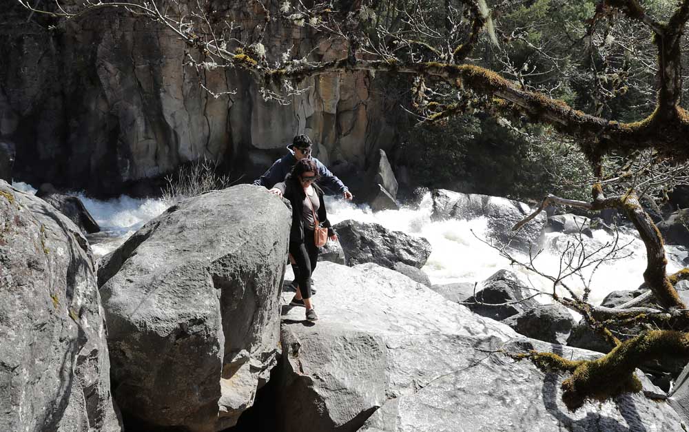
- Hikers navigate along the south side of the Rogue River at Avenue of the Boulders near Prospect in April of last year.
With the weather warming and streams flowing with snowmelt, now’s a good time to visit the Upper Rogue River area near Prospect, where visitors have easy access to three waterfalls and views of the tumbling river as it plunges down a narrow rock-strewn canyon known as Avenue of the Boulders.
Trending
Also near Prospect is a small reservoir created by a power company dam on the river, where the fishing’s great and the Upper Rogue River Trail starts on its southern end.
“They’re all great,” Fred Wickman, co-owner of the Prospect Historic Hotel, said of the waterfalls, river canyon and reservoir areas.
The waterfalls are Pearsony, Mill Creek and Barr Creek.
Trending
Prospect is about 45 miles and an hour’s drive from downtown Medford. The community’s main business area is a quarter-mile off Highway 62, the Crater Lake Highway.
The highway is a segment of the Rogue-Umpqua Scenic Byway, but as far as Wickman is concerned, the better byway is to veer off the highway and take Mill Creek Drive through Prospect.
“Have them come into the hotel,” he said. “We have free maps.”
The hotel, located at Mill Creek Drive and Butte Falls-Prospect Road, serves as something of an unofficial visitor’s center, with Wickman and his crew typically telling visitors about Pearsony Falls, for starters.
“It’s just a 12-minute walk from the front door,” he said. “It’s an easy stroll.”
For those who want to drive to the Pearsony Falls trailhead, take Mill Creek Drive to a Jackson County Parks parking lot at the trailhead, which is about a quarter-mile south of the hotel, near Gun Club Road. The lot is across Mill Creek Drive from the Prospect Store.
The Pearsony Falls site is formerly known as the Prospect State Scenic Viewpoint.
“It’s probably a little-known place,” said Steve Lambert, county parks director.
The trail to the falls is wide and suitable for young and old alike. Wickman describes the trek as a “grandma’s full-tummy walk.” The trail comes to Mill Creek and follows it as it widens and eventually cascades in steps over the falls, which are 12 feet high, according to the Northwest Waterfall Survey.
Mature trees shade the walk and stream. On a hot day, it’s just the spot.
Another five minutes down the trail brings hikers to an overlook at the spectacular Avenue of the Boulders. Watch your step at the overlook and at other overlooks.
The walk back is uphill, but easy.
Also from the trailhead parking lot, another trail leads south about a quarter-mile to the upper end of the Avenue of the Boulders, at a bridge where Mill Creek Drive crosses the river. That trail follows a dirt roadbed through the woods to the bridge, about 10 minutes away.
For anyone who wants to drive to the bridge, there’s parking there, too. The bridge is about a half-mile south of the hotel and a quarter-mile south of the parking lot at the Pearsony Falls trailhead.
From the bridge, there’s a view of Mount McLoughlin on a clear day, as well as views of the tumbling river below.
The Avenue of the Boulders can be viewed from the other side of the river, downstream of the bridge, via a trail reached from another lot off Mill Creek Drive and about a half-mile south of the bridge.
From that lot, the trail winds down a modest slope for a few hundred feet and then forks across relatively flat ground, with the Avenue of the Boulders about a quarter-mile to the left and Mill Creek Falls to the right about a quarter-mile away and Barr Creek Falls beyond that another tenth of a mile or so.
The two falls are across the river from the trail. The view is from the trail. Mill Creek Falls is 173 feet high, while Barr Creek Falls drops 242 feet in three steps.
Yet another attraction near Prospect is a small power company reservoir on the river at North Fork Park, where there’s parking, picnic tables and trout.
“The fishing’s awesome,” Wickman said.
From the reservoir, the Upper Rogue River Trail extends north along the river and through the Rogue River-Siskiyou National Forest to Union Creek, about 11 miles distant, and beyond to the river’s headwaters near Crater Lake.
Reach North Fork Park via an access road that extends west from the highway from a point about 500 feet south of where Mill Creek Drive intersects with the highway on the north end of Prospect. The access road parallels a canal for about a half-mile to the reservoir.
Marketplace

2025 Community Choice Awards

-
eEdition

-

-
