Oregon wildfire ‘hazard map’ comment window ends Aug. 18
Published 5:00 pm Friday, July 26, 2024
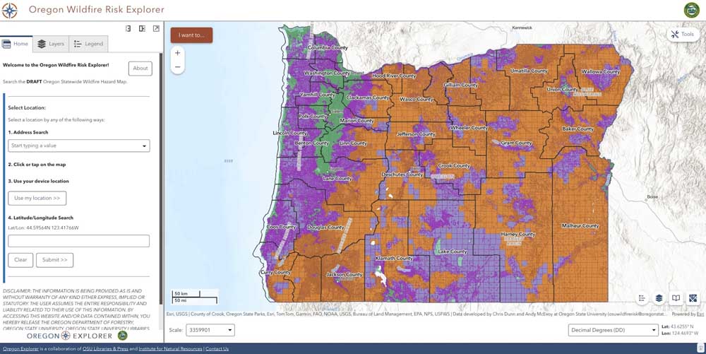
- Oregon's latest drafts of the wildfire "hazard map" and wildland-urban interface map are now online and allow residents to enter their address and see if they will be subject to rules related to home hardening and defensible spaces. People have until Aug. 18 to make public comments on the draft maps.
State officials have released drafts of the proposed wildfire “hazard map” and wildland-urban interface map that break down to the property tax level, giving Oregonians the ability to type in their specific address to see whether they will be subject to rules related to home hardening and defensible spaces.
The release of the draft maps also give residents until Aug. 18 to give input and formally request revisions to the maps of their property. Input may be emailed to hazardmap@odf.oregon.gov.
The latest maps provides more granular detail of the hazard designation of a specific property. According to a pop-up on the Oregon Wildfire Risk Explorer page, the maps are designed to educate Oregonians about their property-level wildfire exposure, to assist in fire adaptation and mitigation resources, and to identify where defensible space and fire-hardening codes will apply.
The state emphasizes that only properties deemed both high hazard and in the Wildland Urban Interface will be subject to fire-hardening building codes and regulations.
Further, in a release issued last week by the Oregon Department of Forestry, Oregon State University wildfire research scientist Alex McEvoy emphasized that they remain just a draft.
“The maps won’t become final until we receive input from counties on potential local anomalies, administrative rules are adopted by the Board of Forestry and we evaluate input from the public,” McEvoy said.
Jackson County commissioners and county officials, however, voiced concerns about the proposed hazard map during a Thursday work session.
County Development Services Director Ted Zuk and County Counsel Joel Benton told commissioners there was “base data that was inaccurate” in the map, and that it was not feedback the state wanted to hear.
As one example, Zuk described how OSU was tasked with tracking burn probability and fire intensity in the map data, but he said there was a lack of data related to fire susceptibility.
He claimed that a litany of objectives the Oregon Legislature ordered in 2021 with the passage of Oregon Senate Bill 762 “were boiled down to probability and fire intensity.”
“And the fire intensity was determined by flame length,” Zuk said, describing how fields have different flame lengths compared to a “forest with a bunch of beetle-killed trees.”
Benton told commissioners that the county obtained a draft of the map about three weeks ago under a nondisclosure agreement so that Jackson County Planning Division staff could provide analysis.
“They wanted planning to basically give it a once-over before it became a public map,” Benton said.
Zuk told commissioners at Thursday’s meeting that the county had been attempting to obtain its copy of the latest draft maps since May.
“There was several weeks of negotiations going on because they wanted a nondisclosure agreement,” Zuk said.
Benton said that the county would not normally agree to an NDA, but he and County Administrator Danny Jordan thought it would be important for development services to have about a month’s time “to actually dive into the map” before it was made available to the public.
Benton said the board has been interested in the wildfire risk map since it was mandated by state lawmakers in 2021. He emphasized that the Thursday meeting was about the map itself, not how it will be used.
Once adopted, the maps will be at the center of laws that — based on how the map classifies a property — will make requirements regarding the property’s development and maintenance, Benton and Zuk said.
“We don’t know the extent of what those other things it’s going to trigger are going to be, because they haven’t wrote the rules for me yet,” Zuk said.
Another focus of the discussion was concerns as to how the state determined structure data on properties to determine whether it’s in the wildland-urban interface.
Commissioner Dave Dotterrer noted, as one example, that Medford City Hall is classified as lying within the wildland-urban interface, but the Jackson County Courthouse building only about a block away is not. An independent search of the hazard map Friday by the Rogue Valley Times confirmed the discrepancy.
“We’re not in the WUI, but the jail is,” Dotterrer said.
Benton noted that the Federal Emergency Management Agency defines the wildland-urban interface as “the zone of transition between occupied land and human development.”
“Well, how much zone of transition is there in the middle of downtown Medford between unoccupied land?” Benton asked.
“If you look at FEMA’s risk hazard map, pretty much all of Jackson County is considered moderate … and this is considered high-hazard,” Zuk said.
In the release issued from ODF, the agency said the updated draft maps reflect “revisions from the last two years based on input received in 2022 from county governments and the public.”
The state highlighted changes to the map that included adjustments for hay and pasturelands, adjustments for forest fuels in northwest Oregon, and changes such as the irrigation of agricultural crops as a “mitigating factor in wildfire hazard assessments.”
Owners in high-hazard zones and within the wildland-urban interface will be notified in early October, and an appeals and hearings process for property owners will go from “Oct. 15 until complete.”
Kyle Williams, ODF’s deputy director of fire operations, said in the release that with one more round of public comments, officials will be ready to finalize a hazard map.
“These drafts are still based on the core principles of wildfire science but have been pored through to address expressed concerns,” Williams said. “With one more round of public input, we well be well situated to finalize a hazard map that will contribute to advancing wildfire protection in Oregon as the Legislature intended.”
Doubts continued at Thursday’s commissioner meeting. Dotterrer asked planning staff if the change from an initial draft wildfire “risk map” — with five categories as first proposed that was met with widespread criticism when it was released in the summer of 2022 — have made much difference compared to the latest draft wildfire “hazard map” with only three classifications.
Zuk said that in one sense it made sense because the “high” and “extreme levels in the first proposed map had no bearing on potential requirements.
“And that put the property owners in a position where they live in ‘extreme’ versus ‘high,’ and what’s that going to do for their insurance, even though insurance is not supposed to look at this?”
State officials have previously disputed the link between the draft wildfire map and tax increases and insurance policy rate increases and cancellations.
Oregon Department of Consumer and Business Services Director Andrew Stolfi, for instance, told commissioners in September 2023 that the rural home property tax increases and policy cancellations that occurred about the same time ODF released the first draft of the wildfire hazard map in August 2022 were not actually caused by the state’s draft map, but rather the insurance industry’s own tools and data.


2025 Community Choice Awards

-
-
-