Sunriver residents under Be Set evacuation notice as Little Lava Fire grows
Published 6:45 am Wednesday, September 11, 2024
- The Backside Fire, located west of Mount Bachelor, on Saturday forced a Level 3-Go Now evacuation notice for areas including Mount Bachelor, Todd Creek Horse Camp, Sparks Lake, Devils Lake and the Quinn Meadow area.
Sunriver was placed under Level 2-Be Set evacuation notice late Tuesday as several active fires continue to burn in the Deschutes National Forest near Sunriver, Mount Bachelor and east of La Pine.
The fires also forced evacuations of several popular recreation areas near Mount Bachelor over the weekend and left residents watching evacuations levels closely.
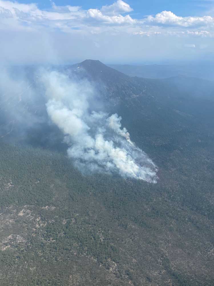
The Bachelor Complex Fire is a group of around 30 fires that range from less than an acre to over 1,000 acres in the Deschutes National Forest near Mount Bachelor. The Little Lava Fire, which grew to over 2,500 acres, is 2 miles southeast of Little Lava Lake and west of Sunriver. Firefighters have built lines using bulldozers to slow the spread of the fire. The Backside Fire, which was 80 acres Tuesday afternoon, had lines all around it and crews were cooling interior hot spots.
Crews were working to improve control lines on Forest Roads 4525 and 45 to slow the spread of the Little Lava Fire. Suppression efforts were underway for other fires in the complex.
The Flat Top Fire, which is southeast of La Pine, grew to around 16,000 acres, said operations chief Nathan Goodrich. It has been fed by dry vegetation on all sides, as well as the wind blowing from the north and northwest. The Cabin Lake Guard Station is secure on the southeast end of the fire.
The Firestone Fire, east of La Pine, grew Monday, with the wind increasing the fire on all sides. It particularly grew in the northeast and was approximately 8,000 acres as of Tuesday afternoon. Firefighters were working to connect roads to be used as containment lines for both the Flat Top and Firestone fires.
Firefighters expected active fires into Tuesday evening. Vegetation is dry and may cause fires to spread even if the wind is low and the weather moderate, fire officials said.
Evacuations
Level 3-Go Now evacuations were in place for:
• Areas around Mount Bachelor south to Forest Road 40, west of Forest Road 41 (Conklin Road), and south of Forest Road 4140.
• South of Forest Road 40, north of Forest Road 42 (South Century Drive), east of Forest Road 4032 and west of the Deschutes National Forest boundary.
• Newly added Tuesday (previously Level 2): East of Forest Road 45 (River Summit Drive) to Forest Road 41 (Conklin Road), south of Century Drive and north of Forest Road 4140, and south of Forest Road 40, north of Forest Road 42 (South Century Drive), west of Forest Road 4210, and east of Forest Road 4032.
Level 3 means leave immediately.
Level 2-Be Set evacuations were in place for:
• Deschutes National Forest east of Forest Road 41 (Conklin Road), west of the Deschutes River, north of Forest Road 40/Spring River Drive and south of Benham Falls, excluding private property, which is Level 1.
• Newly added Tuesday (previously Level 1): Sunriver and areas north of Spring River Road, such as the Besson Road area and Spring River Acres, and east of the Deschutes National Forest boundary south of Spring River Road to S. Century Drive, including River Meadows, Stage Stop Meadows, and Deschutes River Recreational Homesites.
Level 2 means be ready to evacuate at a moment’s notice.
Level 1-Be Ready evacuations were in place for:
West of the Deschutes River from Fall River Estates north to Spring River Road, including Fall River Estates and River Forest Acres.
Newly added Tuesday: West of U.S. Highway 97 south of Lava Butte and adjacent to Sunriver, south to Vandervert Road including the Sunriver Business Park, Caldera Springs, Crosswater and Vandervert Ranch, and Oregon Water Wonderland and Big River Drive area north of S. Century Drive.
Level 1 means be ready for potential evacuation.
A shelter is being set up at the La Pine Community Center, 16405 First St.
Current maps including evacuation areas can be found at deschutes.org/emergency.

2025 Community Choice Awards

-
-
-