Only four counties join Jackson in supporting repeal of wildfire map laws
Published 1:00 pm Saturday, November 9, 2024
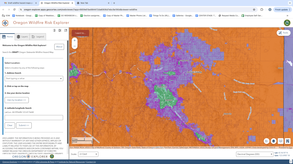
- The Oregon wildfire "hazard map" shows an overview of the Rogue Valley.
Just four of Oregon’s 36 counties opted to join Jackson County commissioners in asking for a repeal of Legislature-backed laws behind a controversial wildfire map that notably drew outcry from rural property owners in the summer of 2022.
Meanwhile, Oregon Department of Forestry spokesman Derek Gasperini says the agency’s “timeline has changed” in the rollout for the final version of the newly-dubbed wildfire “hazard map.” Originally slated for a release in October, along with an appeals process for property owners in high hazard zones, ODF is now anticipating delivery of the final version of the map, along with property owner notifications, by early to mid December.
“The mailing process to send certified notifications to over 100,000 Oregon property owners is far more complex than we originally anticipated,” Gasperini said in an email. He added that ODF plans to release information to the public soon on the updated timing, as well as what property owners can expect from the notification and appeals process.
Jackson County staff told officials at a county work session Tuesday that Douglas, Crook, Yamhill and Umatilla counties were the only ones to respond to a Jackson County request by commissioners seeking support repealing Oregon Senate Bill 762 of 2021 and Senate Bill 80 of 2023.
The law prompted ODF to build wildfire risk maps — which were renamed earlier this year — that the state says are designed to educate residents about where defensible space and fire-hardening codes will apply, and will help prioritize where to prioritize fire adaptation and mitigation resources, according to an earlier news report.
The first draft released in the summer of 2022 prompted numerous complaints and calls for the Oregon Department of Forestry Southwest Oregon District to cancel in-person meetings about the maps due to threats. Property owners claimed at the time that the state map coincided with homeowners insurance policy rate increases and cancellations.
Oregon Department of Consumer and Business Services Director Andrew Stolfi told county commissioners in September 2023 that the insurance policy rate increases and cancellations — although they occurred at the same time the first draft of the risk assessment map was released in August 2022 — stemmed from the insurance industry’s own tools and data.
Jackson County staff and commissioners have previously been very critical of the methodology used to create the latest draft map released earlier this summer.
For instance, in a July meeting, Commissioner Dave Dotterrer highlighted how Medford’s City Hall was classified as being within the wildland-urban interface, but the Jackson County Courthouse building located about a block away was not.
In September, commissioners asked county staff to reach out to other Oregon counties seeking their support on a letter asking for a repeal of the laws. They gave the counties until the end of October to respond.
County Counsel and Senior Deputy County Administrator Joel Benton told commissioners at Tuesday’s work session that the four counties were the only ones to respond. The commissioners voiced dismay, with Commissioner Rick Dyer saying that “only four” was “not super overwhelming,” before deciding to proceed.
Dotterrer acknowledged that the message to Salem would largely be that 31 of Oregon’s 36 counties support the map.
“There’s probably no harm in this, but I just wonder if it’s really going to have much of an impact,” Dotterrer said.
Dyer responded, telling Dotterrer that “it’s never too much.”
Commissioner Colleen Roberts acknowledged to the other commissioners that “it is disappointing” before making the motion to send the letter cosigned by the four counties on to Gov. Tina Kotek, as well as state legislators. Commissioners approved the motion unanimously.


2025 Community Choice Awards

-

-
-