Citizens pack the house in White City to voice concerns over wildfire hazard maps
Published 11:51 am Monday, March 10, 2025


State and local leaders urged property owners to appeal wildfire maps before Monday deadline
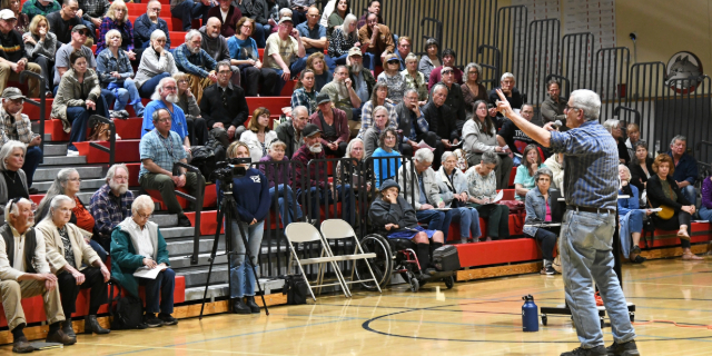
Some 200 community members filled the gymnasium at White Mountain Middle School in White City on Saturday afternoon during a final open house focused on the repeal of wildfire hazard maps created by state lawmakers under Senate Bill 762.
The deadline to appeal the controversial maps is Monday, March 10.
Trending
Saturday’s event maxed out the school parking lot and spilled into surrounding neighborhoods with attendees parking and walking from several blocks away. The crowd was respectful, but emotions were often visibly high during the more than two-hour presentation on the controversial maps.
Retired land use consultant Bob Hart and consultant Jeremy Kauwe presented information on the maps, and several legislators were in attendance, including state Sen. Noah Robinson, R-Cave Junction, state Sen. Jeff Golden, D-Ashland, state Rep. Emily McIntire, R-Eagle Point, and Jackson County Commissioner Colleen Roberts, a Republican.
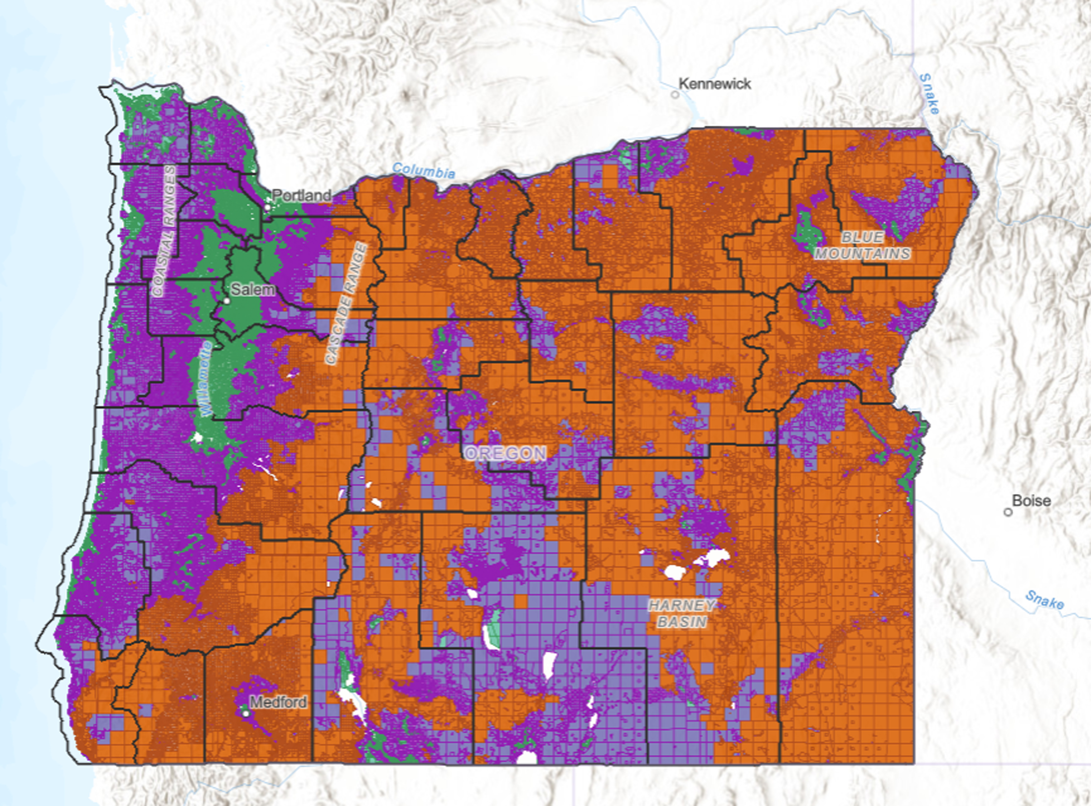
The maps created under SB762 rate properties based on wildfire risk — the higher the rating the more restrictions and heftier fire-hardening standards required to maintain insurance coverage.
Those in attendance voiced concerns about everything from inaccurately rated properties and insurance hikes to limitations on how their properties could be used or modified.
A related bill, Senate Bill 678, would repeal the maps, but those in attendance had mixed reviews over whether SB678, which would reverse provisions created by SB 762, was the best solution.

State and local leaders were on hand for the Saturday town hall , including state Sen. Jeff Golden, left, state Rep. Emily McIntire, state Sen. Noah Robinson and Jackson County Commissioner Colleen Roberts. (Buffy Pollock / Rogue Valley Times)
Robinson, co-sponsor of SB678, urged those in attendance to file appeals against wildfire maps on the ODF website by today. Robinson said he worried for property owners who could be forced off their properties due to rising insurance and fire-hardening costs.
Trending
Phoenix resident Bryan Baumgartner called the maps the result of “the state not looking at all the criteria appropriately” and then applying information incorrectly to properties around the state.
“The Legislature mandated two agencies to deal with this, and they weren’t prepared to deal with it. Bottom line,” he said. “That and it’s an unfunded mandate. So that’s another problem.”
Baumgartner said his irrigated farmland was rated “urban wildland interface,” despite there being no urban wildland interface around his property. He voiced concerns with landowners who didn’t get properly notified that they would be affected, noting, “Is state forestry in the business of dealing with that kind of process? No. So they’re having to figure all that out and we all see how that’s gone.”
Mike Dauenhauer, who lives near Emigrant Lake outside Ashland, said, according to the proposed maps, “it is apparently the most dangerous spot on the planet.”
“If this goes through, I’m gonna have to reroof three houses. I’ll have to re-side one house,” Dauenhauer said. “ I’ve got a creek running right through, by my house, but I can’t legally clear (it) because of the (riparian) offset for the creek.
“The bottom line is, if they’re going to do this, somebody needs to come out and look at every piece of property,” he said.
Jackson County resident Mindy Tiry, who lives above Griffin Creek in rural Medford, said she had utilized wildfire-hardening grants — totaling $24,000 and $11,000 – to maintain insurance coverage but still worried the maps could cause insurance increases and restrict how she uses her property.
“What the maps and all this nonsense is telling me, if my house did burn, I’ve got a 1,300-square-foot mobile and I can’t replace it with a 2,000-square-foot mobile home,” she said. “it says you can’t run a home business either, and I could never be rezoned into urban, or whatever, zoning. … It’s all just too much control on private property.”

Property owner Linda Hansen, bottom right, who lives along Old South Stage Road, voiced frustration with rising insurance costs related to the wildfire hazard maps. (Buffy Pollock / Rogue Valley Times)
Linda Hansen, who lives along Old Stage Road in rural Medford, was visibly frustrated during the presentation. Following the meeting, she said her insurance had already increased by $1,500 per year.
“I’m now spending more on my insurance than you would on a house payment or taxes,” she said.
“But no matter what they do, or whatever law they pass, it won’t undo what they’ve already done, even if it’s wrong. … They opened the can of worms, so now it won’t undo our insurance increases, which have been unbelievable.”
Hansen added, “They say, ‘Oh, well, these poor insurance companies suffered with all these fires and floods. … Give me a break.
“They make millions and millions and millions. … It’s tough for me because I’m on a fixed income and I’m a widow, so they just keep taking more. I feel like they’re making me sell my home because I can’t afford the insurance anymore.”
Commissioner Roberts, who organized Saturday’s town hall, said the key takeaway from the meeting should be to file appeals by Monday and to stay informed.
“If you didn’t get noticed that your property will be affected, still file an appeal. The county had 122 county lots (rated) in high hazard. We got noticed on 31 of them,” she said. “(County staff) called ODF and said, ‘We weren’t noticed on all those,’ and they said, ‘We didn’t have the resources to notice everybody.’”
Roberts said she was hopeful public outcry had been heard, noting, “there’s a lot of people fighting back on this. They expected us just to take it and you know what, we’re not gonna take it.”
Property owners who wish to appeal wildfire hazard classification of their property to the Oregon Department of Forestry must do so electronically. Mailed forms must be postmarked by March 10.
To search a property on the map, visit online.
To file an appeal, visit this site and click on the appeal form.
Reach reporter Buffy Pollock at 458-488-2029 or bpollock@rv-times.com. Follow her on Twitter @orwritergal.
Marketplace


2025 Community Choice Awards

-
eEdition

-

-
