Republicans in Oregon Legislature seek to repeal state’s controversial wildfire risk map
Published 11:57 am Saturday, March 22, 2025
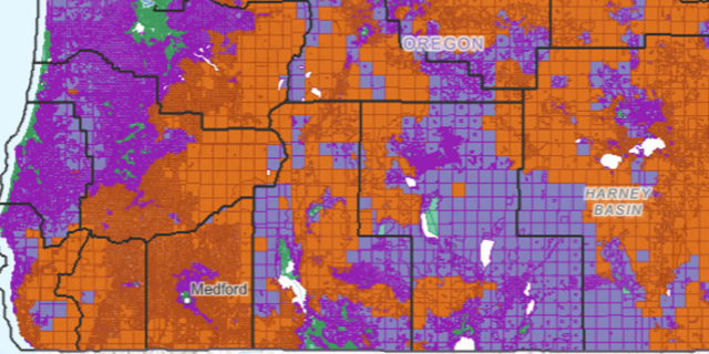
- Screenshot of the wildfire hazard map in southwestern Oregon. Green represents low hazard classification, purple is moderate and orange is high.
Republicans in the Oregon Legislature introduced a bill this past week that would repeal the map showing the wildfire risk for every tax lot in the state.
It’s a map that critics say is rife with mistakes that can reduce property values and force some rural residents to spend more money if they want to build a home on their land.
House Bill 3944 would repeal the map and regulations for landowners whose property is both rated as at extreme risk and is also in the wildland-urban interface, typically an area in or near a fire-prone forest.
Trending
“Oregonians deserve real solutions, not more government overreach,” Sen. Daniel Bonham, R-The Dalles, the Senate Republican Leader, said in a press release. “This new legislation is a unified effort by Republican legislators to repeal the deeply flawed wildfire hazard maps and restore fairness for over 100,000 homeowners. We have an opportunity to correct past mistakes and bring certainty back to property owners across the state.”
“It’s unfair to penalize property owners while our state and federal governments fail to manage our forests and public lands,” said Rep. Christine Drazan, R-Canby, House Republican Leader. “This bill empowers rural Oregonians by allowing them to make decisions on how to manage their properties.”
Creating the map was part of a bill the Oregon Legislature approved in 2021, in the wake of the Labor Day 2020 blazes that destroyed hundreds of homes in Western Oregon.
Several counties have expressed concerns about the map.
The Deschutes County Commission is appealing the map on behalf of all 21,258 properties in the highest designation, a move intended to send a message to state lawmakers as calls to repeal the controversial map continue.
Baker County commissioners urged property owners to file an appeal with the state if their parcels are listed as having a high wildfire risk and are also within the wildland-urban interface. The appeal deadline was March 10.
Trending
At a town hall in White City this month, state legislators and Jackson County Commissioner Colleen Roberts urged residents to do the same thing by the deadline.
Opponents say the map hurts property values, infringes on private property rights and places an undue burden on landowners to deal with wildfire risk.
Residents are also concerned that properties in the high risk category could either lose homeowners insurance or pay higher premiums.
In 2023, the Legislature passed a bill that prohibits insurance companies from using any state wildfire risk map to set premiums or determine whether to insure a property.
Marketplace


2025 Community Choice Awards

-
eEdition

-

-
