BLM reopens Rogue River Trail after blazing new path around big boulder
Published 2:06 pm Monday, April 7, 2025
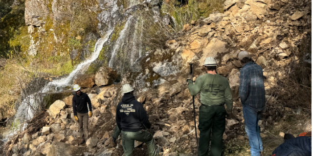
- Rated as "difficult," the Rogue River National Recreation Trail includes hazards such as being remote, having tall cliffs, potential downed trees and more. Photo courtesy of the Bureau of Land Management
The Rogue River Trail has reopened after Bureau of Land Management staff created a path around a large boulder that came down during a landslide two weeks ago.
Wildland firefighters from BLM’s Veteran Crew 10 as well as recreation staff with the bureau cleared the landslide and rerouted the trail around the boulder. Heavy rains in the region caused the slide. The closure affected the BLM-managed portion of the trail from Grave Creek to Marial.
Additionally, crew members removed several downed trees while also addressing other issues along the first few miles of the path.
“The Rogue River Trail is beautiful this time of year, and we worked hard to open it as quickly as possible,” said Grants Pass Field Manager Justin Kelly. “Please watch out for additional hazards as you enjoy your public lands.”
The Rogue River National Recreation Trail is rated as “difficult” due to it being remote, having tall cliffs, the potential for downed trees and other hazards. Hikers could still encounter smaller landslides, unstable footing, eroded areas of the trail and other storm-related impacts. If anyone finds damage on BLM lands, it should be reported to the Medford district office at 541-618-2200.
The trail traverses the wild section of the Lower Rogue National Wild and Scenic River along its entire length. It stretches 40 miles between Grave Creek and Big Bend, offering views of southwest Oregon’s scenic landscapes with steep canyon walls, cascading waterfalls and streams along the Wild Rogue Canyon.
More Outdoors


2025 Community Choice Awards

-
-
-