Prescribed burn cleans up over 60 acres in Ashland watershed
Published 11:00 am Monday, May 12, 2025


US Forest Service teams clear an area earmarked for a burn six years ago; ‘Let’s do our best, as forestry technicians,’ firefighters are told
U.S. Forest Service personnel gathered around a truck with a map of the Ashland watershed pinned to the outside door for a morning briefing to prepare for a prescribed burn to clean up over 60 acres of the Ashland watershed.
Standing around the vehicle at the top of a hill high above the Wonder trailhead Thursday morning, Forest Service Siskiyou Mountains Ranger District leadership staff instructed firefighters in how to conduct the burn for their own safety as well as the town of Ashland below.
Firefighters were told to start at the top and slowly burn their way down the hillside, eventually reaching the bottom over the next two to three days, said Kit Colbenson, a fuels specialist for the Siskiyou Mountain District.
Firefighters were to stay continuously on their radios and in contact with one another, monitoring the progress of each successive line of fire laid down on the fuels on the forest floor.
The firefighters would be broken into two groups, monitored by a burn boss and a holding boss. Those burning would be applying and watching fire, while those holding would be standing at fire breaks such as the road winding up the hill, prepared to catch any runaway fire.

Chris Chambers, Ashland Fire & Rescue Wildfire Division chief, thanks U.S. Forest Service personnel for their work during a briefing before firefighters started a prescribed fire. Ashland.news photo by Morgan Rothborne
‘We’re not in a hurry’
“If you see a spot fire, come to the holding boss and tell us what you got, what you need. Slowing down or ceasing ignition is okay. We’re not in a hurry,” Colbenson said.
Keys to vehicles were left on the dashboard or in the ignition in the event vehicles needed to be quickly moved. Two large foldable vessels of water were positioned at the end of the staging area with hoses attached.
Long white hoses were visible all the way down the hillside, laid by firefighters early that morning to enable quickly putting water where it might need to go. Still, the briefing instructed firefighters to be discerning with their use of water. Additional trucks of water could be called for, but the time to transport could present an issue if water was overused, Colbenson said.
To protect themselves, firefighters are to avoid hiking uphill in the heat and instead rely on a shuttle service to be provided by some firefighters using UTVs, he said. Everyone should stay hydrated, take breaks, try to avoid smoke inhalation and remain vigilant for trees, rocks or debris that could come loose and slide down the steep hillside. The end of the shift would be determined by what bosses “were comfortable with,” in assessing when the area was safe to leave for the night, Colbenson said.
A critical spot in the works for a while
The 63 acres in this prescribed burn are along the border between the city of Ashland’s land and Forest Service land, Ashland Wildfire Division Chief Chris Chambers told Ashland.news in the drive up from the Wonder trailhead. This area is known as Section 6 and had been identified as ready and waiting for a prescribed burn for around six years, as reported by Ashland.news. But aligning resources with the right weather and burning conditions can be challenging.
The downside of suppression forestry
“Native Americans used fire for forest management for thousands of years,” Chambers said. “After 150 years of fire suppression forestry, the data we’ve collected showed three times the amount of trees there should be in some places.”
The city typically would contract with Grayback Forestry for prescribed burns with an “economy of scale” in price, Chambers said. The company offers a “full-service burn,” including prep work and cleanup. Projects smaller than 12 acres can cost as much as $1,100 per acre; larger projects can be worked down to around $700 an acre, Chambers said.
Helicopter logging was costly
The city’s helicopter logging project last year was necessary. However, it ate through most of the funding available for such work in this budget biennium, and only 40% of project costs were recouped through the sale of removed small-diameter timber, he said. This week’s prescribed burn was covered by the Forest Service, with the city providing administrative support.
The Forest Service might have contracted with Grayback as well, but in the face of federal funding changes the USFS instead called in its own resources from the region including, hot-shot crews, he said.
Jen Sanborn, district manager of the Rogue River Siskiyou Office, confirmed the city was contributing only administrative support for this burn. She said she did not have the full financial cost for the project available as she stood with firefighters during the morning briefing.
“This is right against the city, this area is wildland urban interface in spades. This is good training and good experience for our crews and these are the right conditions for a prescribed burn,” she said.
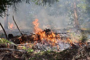
Fuels burned on the ground floor of the forest in the Ashland watershed on Thursday during a prescribed burn. Ashland.news photo by Morgan Rothborne
Burn objectives and tactics
A packet of information provided to firefighters during the briefing and to Ashland.news included detailed weather forecasts. They called for a favorable air mixing height of 6,000 feet — good for dispersing smoke — and rain on Sunday. Operations were slated to conclude Saturday or Sunday; the burn was completed Friday evening, according to a post on the Ashland Fire & Rescue Facebook page.
The objectives for the prescribed burn were also listed in the packet:
- Reduce understory trees (5 inches in diameter) and shrubs by 30% to 40%, reduce litter.
- Reduce light surface fuels by 30% to 80%
- Limit mortality of intermediate trees (5 to 12 inches in diameter)
- Retain 90% of dominant trees (12 inches in diameter)
Minimize mortality of legacy trees (large, more than 150 years old), trees with complex form, large branches, open structure, wide bark plates and providing important habitat features and aesthetic value.
Firefighters broke into their designated holding group or burning group to await further instruction from assigned bosses. For the burning group, Amanda Siano and Jimmy Doris continued giving instructions near the map pinned to the truck with magnets.
‘Stay in communication’
“Know the firefighter to the right or the left of you for accountability and coordination. Stay in communication,” Doris said.
Siano worked with firefighters to AirDrop a map and additional information she had created on her phone to help guide their work.
Firefighters will keep their lines of fire evenly spaced and risk of runaway fire will diminish as “the black,” or area already burned, expands, Chambers said.
After waiting for the weather to warm to give a truer facsimile to burn conditions, crews prepared to conduct a test burn near the tubs of water. Siano stood nearby while firefighters prepared their handheld drip torches.
“Let’s do our best, as forestry technicians,” she told them.
The holding crews went to their positions, waiting with tools near hose lines. The burn crew fanned out and slowly made snaking lines down the hillside with luminous ochre red fire dripping from the torches in their hands. Periodically they slowed or stopped, watching the lines of fire eating away grass, brush and pine needles. The forest slowly filled with fragrant, ambient gray and orange shades of smoke. As the smoke drifted downhill, the blue sky between the trees was obscured and returned to view. In some places the fire licked up the bark at the base of trees but the fire remained on the ground.
To learn more about the research supporting prescribed burning, visit the Oregon State University Extension Service website.
Email Ashland.news reporter Morgan Rothborne at morganr@ashland.news. This story first appeared at Ashland.news.
2025 Community Choice Awards

-

-
-