LATE UPDATE: Fire crews hold line against So. Oregon wildlands blazes; I-5 open with some lane closures
Published 8:07 pm Wednesday, July 9, 2025

- An Avro RJ85 Air Tanker drops fire retardant over the Neil Creek Road Fire in Ashland on July 8. Cedar Barnes / Zuma Images via RVT
Level 2 evacuation orders remain in place for zones near Ashland; Incident Management Team will take over at 6 a.m. Thursday to free up resources
Update 8 p.m.: Fire crews are holding the line on 72 blazes across Southern Oregon after lightning-thick thunderstorms raked the Rogue Valley on Monday night, according to the Oregon Department of Forestry Southwest Oregon District.
“Firefighters are continuing aggressive suppression action across all fires in Jackson and Josephine counties, the majority of which were caused by lightning strikes following thunderstorms Monday night. The fire count remains at 72 total between the two counties, with numerous fires already caught and extinguished at small sizes,” a Wednesday night ODF SWD post said. “The remaining fires are staffed with resources, and progress continues to be made across the board despite hot and windy conditions, which can naturally fuel fire growth. Oregon Department of Forestry (ODF) Complex Incident Management Team 3 was in-briefed by the local district at noon; the team is prepping to take a portion of the fires off the district’s plate as early as 6 a.m. tomorrow morning, freeing up local resources to be ready for potential new fire starts.”
Trending
On Wednesday, according to ODF SWD, the following fires remain the largest incidents across the district:
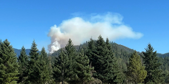
• The Neil Creek Road Fire, located west of I-5 mile marker 10 and south of Ashland. Firefighters have been building and holding lines around the fire despite hot, windy conditions. With the help of additional retardant drops today, firefighters have been able to solidify line around 50% of the fire’s perimeter. Tonight, firefighters will continue to work on holding and improving existing lines and building onto them with a goal of completing as much of the perimeter as possible. The fire is still estimated to be 250 acres. The Jackson County Sheriff’s Office and Emergency Management have placed Zones JAC-536, JAC-542, JAC-543, JAC-546, JAC-558 and JAC-559 under a Level 2 – Be Set to evacuate notice. More information on current evacuations can be found here: https://protect.genasys.com/. One lane of I-5 is closed between mile markers 8.5 and 10.5 on both the southbound and northbound sides. Check tripcheck.com for traffic information.
• The Deming Gulch Fire, located northeast of Buncom, is currently estimated at 250 acres. Firefighters have been able to complete line around 10% of the fire’s perimeter. Steep terrain with limited access is creating challenges for firefighters. Aircraft have been working on the incident throughout the day, providing help to firefighters on the ground. Tonight, two additional bulldozers will be working around the perimeter to continue lining the fire’s edge. There are currently no evacuation notices on this incident.
• The Heppsie Mountain Fire, located south of Highway 140, is now 65% lined and remains at 40 acres in size. Firefighters are continuing to push forward on progress despite the heat and wind. Steep slopes and falling trees continue to be hazards to firefighters on this incident. The Jackson County Sheriff’s Office and Emergency Management have issued a Level 1 – BE READY for a possible evacuation from the following areas: JAC-325-B Heppsie Mountain Road south of Highway 140 and the zone immediately to the south, JAC-326. More information on current evacuations can be found here: https://protect.genasys.com/
• The Poole Hill Fire, located south of the Heppsie Mountain Fire. Firefighters completed their line around the fire’s perimeter today, holding it at a final size of 11.5 acres. Work is continuing to bolster these lines and begin mop-up operations. Evacuation notifications for the Heppsie Mountain Fire apply to this incident as well.
• The North Fork Deer Creek Fire, located in the hills above the 8000-block of Deer Creek Road east of Selma. Firefighters are holding this fire at 42 acres, despite hot and windy conditions. Three 20-person crews, two engines and a water tender have been ordered for tonight’s shift. Resources will work on lining the fire to keep it in its current footprint. There are no current evacuation orders for this incident.
• The Jim Me Peak Fire, located in a remote area south of Applegate. This fire is estimated to be 70 acres and has slightly grown today in hot, windy conditions. Despite this, firefighters have lined 30% of the fire’s edge with a mix of hand-dug line and bulldozer line. Resources will continue to be engaged in an aggressive attack overnight.
• The Palmer Peak Fire, located to the southeast of the Jim Me Peak Fire. Currently estimated to be 90 acres, firefighters have built line around 40% of the fire today. Resources will continue this work overnight.
Numerous other fires are staffed across the district and are being kept at small sizes. Due to the large amount of fires, updates on smaller incidents are not being provided at this time; if conditions change and there are any threats to homes, communities or roads, information will be provided as timely and accurately as possible. Team 3 resources will also provide additional support to public information needs.
“ODF and the Bureau of Land Management (BLM) greatly appreciate the support of our communities during the aggressive firefight that has ensued since Monday evening,” the post said. “Local firefighters and resources have been working around the clock since the first reports of smoke were taken, and the outpouring of support from southern Oregon is seen, heard and felt, providing continued motivation to the boots on the ground.”
High fire danger is currently in effect on ODF-protected land in Jackson and Josephine counties; as firefighters work to extinguish these natural fire starts, help prevent new human-caused fires from sparking by following all regulations currently in place: https://swofire.com/public-fire-restrictions/
For fire information anytime, visit the ODF SWD Facebook page, @ODFSouthwest on X or www.swofire.com.
Update 6:15 p.m.: A northbound lane of Interstate 5 heading to the Siskiyou Summit is closed because of the Neil Creek Road Fire, according to the Oregon Department of Transportation.
Trending
A southbound lane has been closed since late Tuesday night.
See tripcheck.com for updates.
Update 1 p.m.: Ashland.news reports that roughly 60 to 100 homes are at risk in the Neil Creek Road area, according to Kelly Burns, Ashland’s emergency management coordinator. He said the blaze also threatens Ashland’s watershed and other recreation areas.
The Neil Creek Road Fire south of Ashland and west of Interstate 5 is at 250 acres and has caused the closure of one southbound freeway lane, the Oregon Department of Forestry Southwest District reported Wednesday morning.
Reach Rogue Valley Times Editor Troy Heie at troy.heie@rv-times.com
Marketplace


2025 Community Choice Awards

-
eEdition

-

-
