UPDATE: ODF preps crews as thunderstorms arrive amid Red Flag Warning
Published 11:59 am Wednesday, July 30, 2025

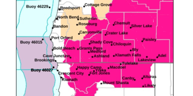
- National Weather Service image
Update 3:28 p.m.: The Oregon Department of Forestry Southwest Oregon District says it is prepared for thunderstorms and the potential for lightning that is arriving from Northern California.
“ODF is always ready to respond to reports of fire, and anytime there are potential thunderstorms in the forecast, we’re gearing up for what could be multiple new fires,” a Wednesday afternoon post said. “All of our engines will be staffed this afternoon and in their patrol areas for a fast response. Our Detection Center staff are continuously monitoring cameras across the district for any new signs of smoke or fire; if lightning comes through, they will watch those areas closely and make reports to our dispatch center when needed. We’ll also launch aircraft for reconnaissance missions over strike areas if storms materialize.”
Update 2:38 p.m.: Five storm cells blowing through Siskiyou County are heading toward Southern Oregon and the Rogue Valley amid a Red Flag Warning for heightened fire danger.
Trending
The latest National Weather Service radar loop shows the cells moving to the northwest from the southeast.
See previous coverage below
Thunderstorms are brewing to the southeast of the Rogue Valley, moving to the northwest as officials warn about heightened wildfire risk.
The National Weather Service in Medford has issued a Red Flag Warning from 2 to 11 p.m. Wednesday for areas of Southern Oregon and Northern California. The latest radar shows storms developing in eastern Shasta and Siskiyou counties and near Mt. Shasta City in Northern California.
“The next round of thunderstorms will spread out across Southern Oregon and Northern California this afternoon and
evening,” a Wednesday late morning post said. “Storms will continue into the overnight hours and become more isolated in northern Lake and Klamath Counties with perhaps one or two west of the Cascades. Another round of thunderstorms will develop Thursday afternoon and evening.”
The National Weather Service office in Medford predicts abundant lightning on dry fuels as thunderstorms move into the region.
Trending
“Isolated to scattered thunderstorms with abundant lightning are possible,” the NWS-Medford post Wednesday said. “Storms are likely to be wet, but lightning strikes outside of precipitation cores are possible, and cause for concern for new fire starts.”
View the hazard area in detail at https://www.wrh.noaa.gov/map/?wfo=mfr. Check weather.gov/medford for forecast updates.
Areas in Southern Oregon under the warning are the eastern Rogue Valley, western Rogue Basin that includes the Illinois Valley, and the Siskiyou Mountains. In Oregon, the warning includes fire weather zones 620, 621 and 622. Areas of Northern California, from Happy Camp to Alturas, also are under the warning.
Gusts of 35 to 50 mph could travel outward up to 25 miles from thunderstorm cores, forecasters warned.
The weather service urged residents and businesses to follow all fire restrictions and avoid activities that could cause sparks.
“If you have not packed your go kit yet, now is the time to do so,” the post said. “This includes items like important documents and essentials you cannot live without. Fill your vehicle’s fuel tank. Visit ready.gov/kit for more information.”
Reach Rogue Valley Times Editor Troy Heie at troy.heie@rv-times.com.
Marketplace


-
eEdition

-

-
