Cougar Creek, Rattlesnake Ridge fires force evacuations in Douglas County
Published 5:45 am Sunday, August 27, 2023
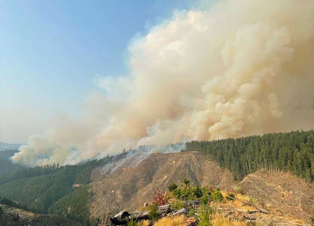
- Fires in the Tyee Ridge Complex in Douglas County had burned 1,800 acres as of Sunday morning and forced Level 3 evacuation orders.
UMPQUA — The Cougar Creek and Rattlesnake Ridge fires — the two largest fires to emerge from the Tyee Complex, a group of 19 fires which ignited due to a lightning storm Thursday night — had burned approximately 1,800 acres as of Sunday morning in the steep terrain around the Tyee/Umpqua area, according to the Douglas Forest Protective Association.
The fires forced the Douglas County Sheriff’s Office to issue a Level 2 “BE SET” evacuate notice at approximately 3 p.m. Saturday for all residences on Lighthouse Road in Tyee.
A Level 3 evacuation — signaling there is extreme danger and residents should leave immediately — was issued at 5:30 p.m. Friday for those living in the area from the 10,000 block of Hubbard Creek Road to the intersection of Hubbard Creek Road and Millwood Drive. Three hours later, at 8:45 p.m., DCSO updated the evacuation notice to include the 11,000 block of Hubbard Creek Road, continuing to the intersection with Millwood Drive.
According to the Douglas County GIS Wildfire Information Map, 72 addresses were located in the Level 3 evacuation area, including a total of 182 residents.
A Level 2 “BE SET” order was also put in place for residents living between the Millwood intersection and Melqua Road, an area that includes 31 addresses and 78 residents. All residences on Briarwood Lane were also given a Level 2 order. A Level 2 evacuation order means that residents should be ready to evacuate on a moment’s notice.
On Friday evening, the American Red Cross opened a disaster relief shelter in the gymnasium of Oakland Elementary School, located at 499 NE Spruce St. in Oakland. The Douglas County Fairgrounds complex opened its doors as a shelter for livestock and large animals, while Saving Grace Pet Adoption Center served as a shelter for companion animals. On Saturday, Sutherlin City Manager Jerry Gilham announced that the city’s rodeo grounds, at 250 S. State St. in Sutherlin, would also serve as a shelter for livestock and large animals.
Frances Hernandez, who has worked for the American Red Cross for over 30 years and served as the supervisor at the disaster shelter operated by the Red Cross on Saturday, said only one person was known to have used the shelter as of Saturday morning, a person who eventually found somebody in town to take them in. By 11 a.m. Saturday, the shelter was empty, apart from Red Cross workers.
“An empty shelter is a good sign,” Hernandez said.
Hernandez said those who need access to the disaster relief shelter can get a secure place to sleep, food and access up to date information. The shelter is open 24/7 with Red Cross staff available to help at any time, she said.
It is unknown how long the shelter will be open.
“The Red Cross can turn on a dime,” Hernandez said. “It might close here and open up somewhere else. We can do that. Wherever it’s needed to jump on, we have trailers and we’re ready to go.”
The Douglas Forest Protective Agency said that fire crews worked overnight and prioritized focus on the fire activity happening near the southeast ridge, an area threatening nearby homes and structures. That area, DFPA said, is in steep terrain, with snags and abundant fuels. Fire behavior, despite the higher relative humidity and cooler temperatures, DFPA said, remained active through the night.
The Oregon Department of Forestry Incident Management Team was scheduled to take command of the incident at 6 p.m. Saturday.
Fire crews saw active fire growth Saturday night on the Cougar Creek and Rattlesnake Ridge fires, which grew together, according to a Sunday update from the team fighting the fires.
“There was also very active fire, including uphill runs on the Lighthouse 3 and 4 fires,” said the written update. “Overnight, (Oregon State Fire Marshal crews provided protection from active fire to homes near the fires. … There is potential for significant fire growth on some of the fires over the next couple of days. One new fire start was found (Saturday) evening and added to the complex.”
No homes were confirmed to have been burned as of Sunday morning, the report stated.
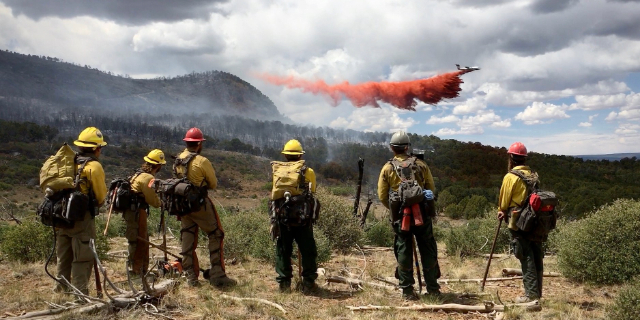
Challenges facing firefighters include steep terrain, limited road access, warm weather, heavy smoke and extremely dry conditions. Ten helicopters have been dropping water on the fires in support of ground forces, but heavy smoke and low visibility has limited use of fixed-wing aircraft, the report stated.
Firefighters and equipment was expected to continue arriving Sunday from around Oregon and nationally to support forces on the Tyee Complex, which is about 20 road miles northwest of Roseburg. Two more Oregon State Fire Marshal structural task forces — one from Clatsop County Sunday morning and one from Yamhill Sunday afternoon — were expected to join the five already at the fire.
A total of 73 residences are under Level 3 (Go Now!) evacuation orders and 31 at Level 2 (Be Set). An estimated 125 people have evacuated from the Hubbard Creek Road area west of the town of Umpqua. Douglas County Emergency Management has worked with the Red Cross to set up a shelter for evacuees at the Oakland Elementary School at 499 NE Spruce Street in Oakland. To shelter livestock, contact Douglas County Fairgrounds at 541-957-7010. Companion pets can be sheltered at Saving Grace animal shelter in Roseburg. Evacuation areas remain unchanged. To view the current evacuation information map, go to www.dcso.com/evacuations
A community meeting is scheduled at 7 p.m. Monday at the Roseburg Country Club, 5051 Garden Valley Road, Roseburg.
On Friday, Oregon Gov. Tina Kotek invoked the Emergency Conflagration Act for the Tyee Ridge Complex to allow the Oregon State Fire Marshal to mobilize resources to protect life and property, according to a press release from the Oregon State Fire Marshal released Saturday morning. The OSFM firefighters and equipment will provide structure protection for homes threatened by the Cougar Creek and Rattlesnake Ridge fires.
“Oregon received a significant amount of lightning over the past 36 hours, starting many fires,” said Oregon State Fire Marshal Mariana Ruiz-Temple in a press release. “With Oregon in the heart of fire season, this conflagration declaration allows the OSFM to mobilize structural firefighting resources through the Oregon Fire Mutual Aid System (OFMAS) to help protect the communities impacted by the Tyee Ridge Complex.”
The Douglas County Sheriff’s Office evacuation map is available at dcso.com/evacuations. Sign up for emergency notifications through Douglas County Citizen Alert at dcso.com/alerts.
Regular updates from a designated Oregon Department of Forestry Incident Management Team public information team for the Tyee Ridge Complex Fire can be found at facebook.com/tyeeridgecomplex.

2025 Community Choice Awards

-
-
-