Fall a lovely time to visit Boundary Springs near Crater Lake
Published 3:30 pm Wednesday, September 27, 2023
- For many years, it was believed that Crater Lake was the source of the Boundary Springs' waters, but it's actually snowmelt that gets the credit.
Having just come off a grueling backpack trip circumnavigating Mount Rainier on the Wonderland Trail, I was looking for a scenic, easy hike to stretch my legs and shake off the rain of Washington. I chose the Boundary Springs Trail — a rewarding, 5-mile round-trip taking the hiker from the Rogue River National Forest into Crater Lake National Park and the headwaters of the Rogue River bubbling up out of Boundary Springs.
Trending
This trailhead is a 90-minute drive south of Bend. If you combine it with another short hike in the Diamond Lake area or an accompanying visit to Crater Lake, it’s the perfect activity for a day or an overnight.
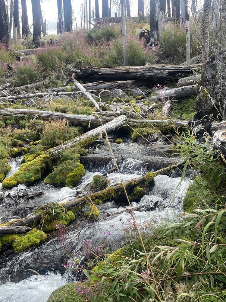
The hike starts at the Mazama Viewpoint pullout along Highway 230, a few miles west of the Diamond Lake junction. Because there are no signs on the road advertising this as a trailhead, many potential hikers discover it only by parking to use the available outhouse. Take a few moments to read the sensational informational placard describing the eruption of Mount Mazama over seven centuries ago. This same eruption that created Crater Lake also buried the existing headwaters of the Rogue under a pile of hot pumice. Over time, the river re-created its pathway by carving a 100-foot canyon. The trail goes along this canyon.
The trailhead is located to the right of the outhouse, and the sign announcing the Upper Rogue River Trail No. 1034 is barely legible. Boundary Springs Trail No. 1057 turns off of the main Trail about a ½-mile in. We headed steeply down for about 100 yards before leveling off into forest burned in 2015. We followed along the ups and downs of the trail, admiring the burned silver snags surrounded by green, young lodgepole pine and Shasta red fir. At a ½ mile, we came to a junction. Nailed to a nearby tree, a very faded sign with an etched arrow identified the trail switch-backing sharply left as heading to Boundary Springs. The Upper Rogue River Trail continues straight, though it looks difficult to follow now.
Trending
We headed left and dropped quickly down into a narrow canyon, crossing a small tributary creek on helpfully placed logs. We snacked on a few huckleberries from the surrounding bushes before heading back up the other side to another switchback at the top of the hill. From this vantage point, we got our first good view of the Rogue River below.
We walked above the river, angling downwards to meet dirt road 760 at 1 mile from the trailhead. A previous thoughtful hiker had made a stick arrow pointing us to the right along the dirt road as we crossed over the Rogue River and to the continuation of the trail on our left.
After 2020 fire, nature is healing at Green Ridge Trail
For taking in Central Oregon scenery, snowshoes set the right pace
The trail heads narrowly up and down along the canyon over the next mile, crossing into Crater Lake National Park at 1.5 miles. We encountered several easy-to-crawl-over fallen trees across the trail. At 2 miles, we dropped down next to the river into my favorite section of trail. This section guides the hiker along well-defined trail bordered by rocks, huckleberry bushes and vibrant fireweed. Just below Boundary Springs, a thundering, short waterfall crashes down.
At 2.5 miles, we came to the junction of Boundary Springs trail and the Bald Crater Loop trail heading further into the park. The wooden sign that usually marks the junction was broken and lying on the ground, pointing to the left. We crossed over a small spring and followed the trail around a low ridge to just below where the Rogue springs forth out of the side of the ridge. For many years, it was thought that Crater Lake was the source of Boundary Springs, but it is actually fed by snowmelt.
We ate our lunch while appreciating the views and then headed back to the trailhead. Our total hiking time was three hours and we only saw a few other hikers. I’ve done this hike several times before, most recently enjoying the spring flower displays. The 2015 fire opened up the trail, so it can get hot mid-day in the summer months. Summer can also be a bit buggy. Fall is a lovely time to hike the trail without having to worry about either heat or bugs.
The trail is usually snow-covered starting in October and through to July, even though Highway 230 remains open. Driving and hike details can be found in William L. Sullivan’s 100 Hikes/Southern Oregon series and on the AllTrails app.
Marketplace


2025 Community Choice Awards

-
eEdition

-

-
