Three in one: A trio of waterfalls in two miles on the McCloud River Trail
Published 10:45 am Thursday, November 2, 2023
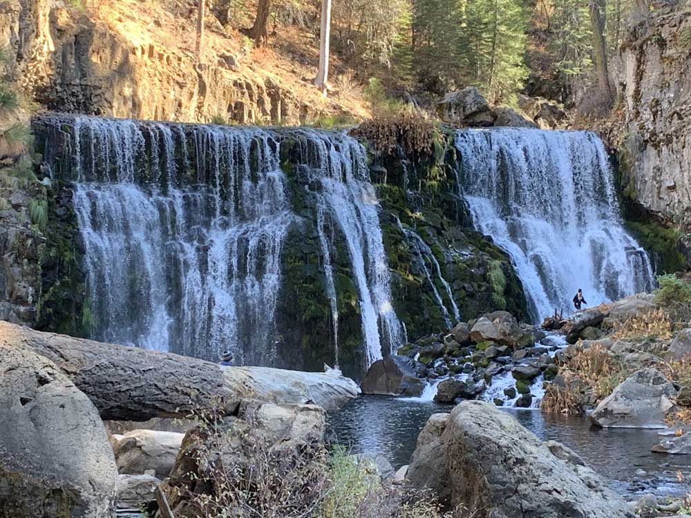
- Middle Falls is the most spectacular sight along the McCloud River Trail.
Some trails are too tempting to pass up.
Trending
That’s an apt description of the McCloud River Trail, a two-mile, one-way hike in Siskiyou County, California, that offers views of the river’s Lower, Middle and Upper falls on a mostly easy, well-defined trail. The waterfalls can be seen in sections, as a one-way jaunt with cars parked at either end, or, best of all, on an out-and-back hike.
It’s along the McCloud River Trail, that the water has carved its way through an often deep canyon of cooled lava flows and columnar basalt, creating the trio of distinctly different waterfalls.
Our hike began from a parking lot at the Lower Falls picnic area. The sights from a viewpoint are alluring. According to interpretive signs, Native Americans said the Lower Falls is where the fish stopped, their passage halted because they could not leap up the 15-foot-tall falls. On warm summer days, some people cross over river rocks alongside the falls, where the river pours into a deep pool, and jump in. There were no swimmers on this fall day.
Trending
With Neil Barrett and Mary Beth Lee leading the way, Liane Venzke and I began at the Lower Falls trailhead to walk upriver, the better way to see and appreciate the trio of waterfalls. The McCloud River actually begins from some springs several miles upriver, but its volume greatly benefits from water flowing off Ash Creek and Mud Creek, which are fed by water from nearby Mount Shasta.
The trail upriver to Fowlers Camp is paved, mostly level and ADA-compatible. From the main trail, several user trails provide peeks of the river as it continues to the Fowlers Creek Campground. It’s well-located, with campsites just steps away from the river overlooks.
Past the campground, the trail becomes a well-maintained dirt path that mostly follows alongside the river. It’s a beautiful section, with large old-growth Douglas firs and occasional Pacific Yews providing a shady canopy. As the trail moves upriver, the sound of Middle Falls becomes louder and bolder, foreshadowing what’s to come.
What comes is beautiful Middle Falls. Approaching the falls — which plunges about 50 feet down at span 80 feet across — the initial glimpses through the trees looks like water cascading through wide curtains. Closer to the falls, the sights and sounds are even more awe-inspiring as the broad sheet of water noisily plunges downstream.
Amazing, too, were a young couple who teetered across river rocks, eventually reaching the opposite side near the falls where, in apparent celebration, they took turns doing handstands and cartwheels. More impressively, they later worked their way back across the rumbling river, making their way ballerina-like from one often small river rock to another before settling on an outcrop with a river view where they snuggled and savored from their well-earned perch.
We stayed further away.
After enjoying our own views and a quick lunch, we continued upriver, following the trail, which switchbacks and climbs a staircase up and above Middle Falls. On top, where the trail follows the steep-edged rim, trail builders thoughtfully — and necessarily — installed railings. The path continued above the canyon, with a series of overlooks offering sightings of the Upper Falls, which pour over a 50-foot-high basalt wall. An added bonus were westerly sightings of the high peaks of the Castle Crags Wilderness and, looking northeast, the southwest side Mount Shasta.
The return hike to the Lower Falls picnic/parking offered different perspectives of the river and the falls. As we dropped back into the sun-shaded canyon below Middle Falls, temperatures cooled, especially where a light breeze lightly filtered the air with moisture from the falls.
Our triple-header was well worth the drive.
To reach the Lower McCloud River Trailhead/parking area, take Interstate 5 south of Mount Shasta City to exit 736 toward McCloud. Drive on Highway 89 about 15 miles past McCloud. At the well-signed turnoff for Forest Service Road 40N44, follow the signs to Lower McCloud Falls about 1.3 miles to the McCloud River picnic area.
As an added bonus we extended our trip by going south on Interstate 5 to Exit 732 — Siskiyou Avenue, Dunsmuir Avenue and Hedge Creek Falls — to the Hedge Creek Falls parking area.
It’s easy to miss. Immediately take the first right onto Dunsmuir Avenue, just a short distance to the parking area on the right.
It’s just a short walk past a gazebo and down a switchback path to the falls, which tumble 20-feet into a small pool. The trail curls under the falls into and through a small cave behind the falls. Past the falls, the trail reaches a second gazebo along the Sacramento River Canyon. Because Hedge Creek is mostly fed by an underground aquifer, its water flows year-round. The round-trip distance is a little more than a half-mile.
Marketplace


2025 Community Choice Awards

-
eEdition

-

-
