Dixon Fire displaces residents in Tiller; community meeting slated for Wednesday
Published 2:30 pm Tuesday, August 13, 2024
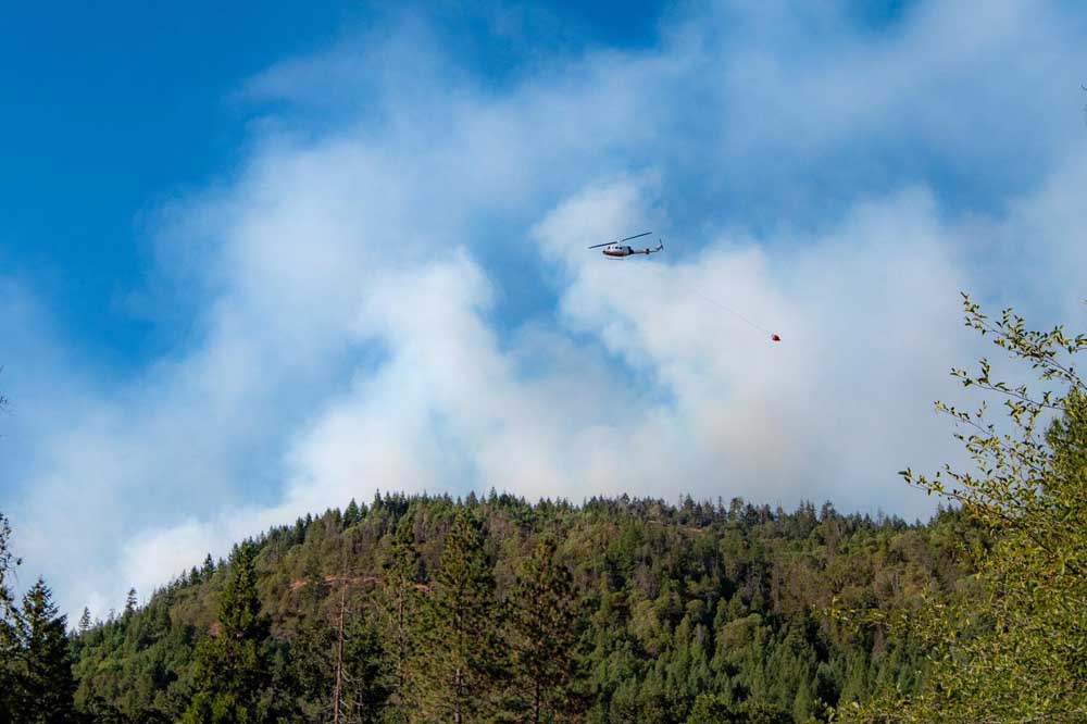
- Aerial crews help combat the Dixon Fire in the Tiller area.
TILLER — Oregon Department of Forestry Incident Management Team 2 and the Oregon State Fire Marshal Green Team took unified command of the Dixon Fire on Monday.
Trending
The Dixon Fire started around 2:40 p.m. Saturday in the area near Tiller and Drew in southern Douglas County, less than 40 miles north of Shady Cove. The fire, which was initially called the Tiller Trail Fire, quickly grew and by Tuesday morning was 1,997 acres in size and 0% contained.
There was one home destroyed Saturday.
Douglas County Sheriff’s Office issued several evacuation notices and as of Tuesday, 18 structures fell under a Level 3 — Go Now— evacuation, 13 structures were under Level 2 — Be Set — evacuation orders and 18 structures received Level 1 — Be Ready — notices. An emergency shelter was set up at Days Creek Charter School, 11381 Tiller Trail Highway in Days Creek.
Trending
A community meeting is scheduled for 7 p.m. Wednesday at South Umpqua Community Church, 27292 Tiller Trail Highway in Days Creek.
The Umpqua National Forest issued a closure due to the Dixon Fire on Monday. This closure prohibits being on the road or going into the area closed in the Tiller Ranger District.
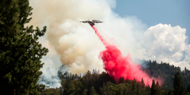
“Today, firefighters took advantage of cooler morning temperatures to engage with the fire and continued to establish control line,” a Monday evening press release said. “In the afternoon, fire activity increased substantially, and air assets were heavily utilized to assist with suppression. Structure resources provided point protection on several properties due to fuels burning in the area.”
The Tiller Trail Highway is closed between South Umpqua and Devil’s Knob due to the fire.
Fire crews plan to remove hazardous trees along the Tiller Trail Highway on Tuesday, which may cause extended delays.
For an interactive map of evacuations, visit dcso.com/evacuations.
The sheriff’s office said 24-hour patrols will continue at the properties under the evacuation notices. “Deputies are remaining vigilant and will take enforcement action against anyone who would take advantage of those who are enduring this emergency,” Lt. Brad O’Dell said.
Diamond Complex and Middle Fork Fire
Crater Lake National Park will close the north entrance road in the park beginning Tuesday for firefighters to prepare control lines for the Middle Fork Fire. Highway 230 along the northwest corner of the park will be one-lane traffic with a flagger and pilot car due to the fire work.
The Middle Fork Fire was approximately 5,039 acres and 0% contained Tuesday morning. Crews continued road preparation, clearing vegetation, installing hose lays and air resources remain available. Firefighters watched for uphill runs at Devils Ridge throughout Monday and hot spots were revealed to the southwest.
Middle Fork Fire and Diamond Complex, a group of 27 lightning-caused fires in the Diamond Lake Ranger District, are sharing resources.
The Diamond Complex is approximately 8,466 acres. The 734 people assigned to the complex continue to fight spot fires, prepare roads and control lines, and mop up where able.
An evacuation notice was downgraded to a Level 1 — Be Ready — notice Monday by the sheriff’s office for all homes in the Slide Creek area downstream to the Soda Springs area due to the Pine Bench Fire, 2,221 acres and 51% contained.
Homestead Complex
The Homestead Complex totals 4,387 acres with 14% contained and 588 personnel assigned to the fires about 30 miles east of Glide.
Infrared flight in the early hours of Monday morning revealed the Horse Heaven Creek Fire, 1,201 acres, had crossed Windy Creek, so crews worked on putting line in the north and east and utilizing burnout operations originally scheduled for Tuesday. The Reynolds Butte Fire, 335 acres, was close to patrol status.
Marketplace


2025 Community Choice Awards

-
eEdition

-

-
